
-
摘要:
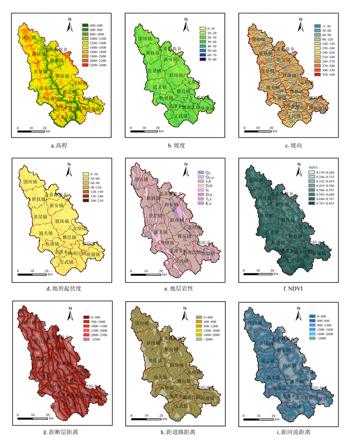
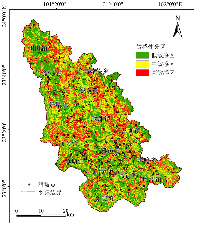
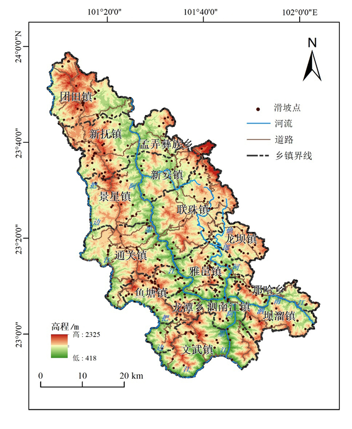
为了使滑坡敏感性分析结果更为准确,选取科学的分级方法以及构建合理的评价模型是关键。以云南省墨江县作为研究区,选取9项影响因子,通过频率比法对滑坡影响因子进行分级,利用证据权法—皮尔逊积矩相关系数模型(WOE-PPMCC)对滑坡影响因子敏感性进行分析,并验证分析结果的准确性,对墨江县滑坡进行敏感性分区。研究结果表明:1)影响因子敏感性由高到低分别为坡向、断层、道路、坡度、河流、高程、地形起伏度、地层岩性、NDVI;2)研究区域可划分为低敏感区、中敏感区、高敏感区,分别占总面积的40.69%、30.56%、28.75%,各分区分别发育有8处、43处、332处滑坡,各敏感性分区内滑坡点的比例呈现出随敏感性等级的升高而依次递增的良好正相关性;3)WOE-PPMCC模型精度高,数据分析结果准确可靠,实现了用较少的高敏感区来尽可能多地体现已知滑坡点的目的。该方法适用于指导防灾减灾实际工作,研究结果可为滑坡灾害的综合防治提供依据。
-
关键词:
- 滑坡 /
- 频率比法 /
- WOE-PPMCC模型 /
- 敏感性分析 /
- 墨江县
Abstract:To improve the accuracy of landslide sensitivity analysis, it is crucial to select scientific grading methods and construct reasonable evaluation models. Taking Mojiang County, Yunnan Province as the research area, this study selected nine influencing factors. The frequency ratio method was used to grade the landslide influencing factors. The Weight of Evidence-Pearson Product-Moment Correlation Coefficient (WOE-PPMCC) model was employed to analyze the sensitivity of landslide influencing factors and validate the accuracy of the analysis results, aiming to partition the sensitivity of landslides in Mojiang County. The results show that: 1) the sensitivity of influencing factors, in descending order, is aspect, fault, road, slope, river, elevation, terrain roughness, lithology, and NDVI. 2) The study area can be divided into low sensitivity, medium sensitivity, and high sensitivity zones, accounting for 40.69%, 30.56%, and 28.75% of the total area, respectively. These zones contain 8, 43, and 332 landslides, respectively. The proportion of landslides within each sensitivity zone shows a good positive correlation, increasing with higher sensitivity levels. 3) The WOE-PPMCC model has high accuracy, and the data analysis results are accurate and reliable, achieving the purpose of using fewer high sensitivity zones to represent as many known landslide points as possible. This method is suitable for guiding disaster prevention and mitigation work, and the research results can provide a basis for the comprehensive prevention and control of landslide disasters.
-
Key words:
- Landslide /
- Frequency ratio method /
- WOE-PPMCC model /
- Sensitivity analysis /
- Mojiang County
-

-
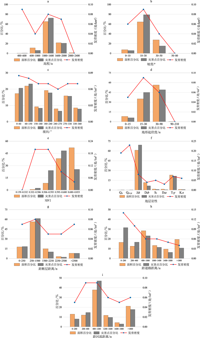
图 3
影响因子分级统计结果图
Figure 3.
The results of statistical classification of influencing factors
表 1
高程频率比法计算结果
Table 1.
Calculation results of elevation frequency ratio
高程/m 区间面积/km2 滑坡面积/m2 FR 400~600 22.46 750 0.01 600~800 135.69 205400 0.67 800~1000 458.60 677430 0.66 1000~1200 932.61 2602363 1.24 1200~1400 1262.32 2941569 1.04 1400~1600 1265.55 3367662 1.18 1600~1800 810.41 1689357 0.83 1800~2000 350.93 461769 0.69 2000~2200 70.50 0 0 2200~2400 2.21 0 0  下载: 导出CSV
表 2
影响因子分级结果
Table 2.
Classification results of hazard-inducing factors
分级 影响因子 高程/m FR 坡度/° FR 坡度/° FR 地形起伏度/m FR NDVI FR 地层岩性 断层距离/m FR 道路距离/m FR 河流距离/m FR Ⅰ 400~600 0.01 0~10 0.38 0~60 1.07 0~15 0.53 0.159~0.332 0 粘土、砂土、卵砾石多层土体(Qal) 0~250 0.83 0~200 0.75 0~200 1.15 Ⅱ 600~1000 0.66 10~30 1.23 60~150 0.7 15~30 1.54 0.332~0.506 1.29 粘质砂土、砂质粘土、砾石多层土体(Qal+pl) 250~1500 1.25 200~400 2.53 200~400 0.60 Ⅲ 1000~1600 1.15 30~50 0.72 150~180 1.04 30~90 0.61 0.506~0.593 2.74 较软中厚层泥岩、粉砂岩(J2h) 1500~2250 0.74 400~1000 1.30 400~1200 1.43 Ⅳ 1600~2000 0.76 50~80 0 180~240 0.69 90~210 0 0.593~0.680 1.34 较坚硬中厚层砂岩、泥岩(D2b) 2250~2500 1.13 1000~1400 0.65 1200~1600 0.65 Ⅴ 2000~2400 0 - - 240~270 1.12 - - 0.680~0.853 0.27 较坚硬中厚层千枚岩、石英砂岩(S3) >2500 0.1 1400~1800 1.00 1600~1800 2.11 Ⅵ - - - - 270~330 0.77 - - - 坚硬层状灰岩、白云岩(D2a) - - >1800 0.15 >1800 0.42 Ⅶ - - - - 330~360 2.63 - - - 坚硬块状砂岩、长石石英砂岩(T3y) - - - - - - Ⅷ - - - - - - - 坚硬块状岩浆岩(K1s) - - - - - -
下载: 导出CSV
表 3
各影响因子分类等级Wc值计算结果表
Table 3.
Calculation results table of Wc of classification level of each evaluation factor
影响因子 分级 灾害点/处 Wc值 影响因子 分级 灾害点/处 Wc值 高程/m 400~600 2 0.214 地层岩性 Qal 1 0.642 600~1000 24 -0.627 Qal+pl 1 0.358 1000~1600 277 1.31 J2h 265 1.298 1600~2000 80 -1.159 D2b 25 -0.631 2000~2400 0 -0.014 S3 4 -0.391 坡度/° 0~10 22 -0.286 D2a 2 -1.027 10~30 303 0.735 T3y 82 0.699 30~50 58 -0.004 K1s 3 -0.230 50~80 0 -0.759 距断层距离/m 0~250 70 0.038 坡向/° 0~60 79 0.215 250~1500 235 0.207 60~150 89 0.075 1500~2250 39 -0.438 150~180 32 -0.109 2250~2500 8 -0.352 180~240 68 -0.097 >2500 31 0.009 240~270 25 -0.212 距道路距离/m 0~200 121 0.847 270~330 60 -0.016 200~400 64 0.328 330~360 30 -0.087 400~1000 89 -0.270 地形起伏度/m 0~15 23 -0.338 1000~1400 44 -0.168 15~30 172 0.410 1400~1800 24 -0.464 30~90 188 0.296 >1800 41 -0.706 90~210 0 -0.002 距河流距离/m 0~200 31 -0.525 NDVI 0.159~0.332 0 0.000 200~400 56 0.226 0.332~0.506 9 1.053 400~1200 180 0.377 0.506~0.593 92 0.391 1200~1600 37 -0.209 0.593~0.680 185 1.229 1600~1800 11 -0.459 0.680~0.853 97 -1.160 >1800 68 -0.212
下载: 导出CSV
表 4
滑坡影响因子敏感性分析表
Table 4.
Analysis of susceptibility of disaster-causing factors
相关系数 高程 坡度 坡向 地形起伏度 NDVI 地层岩性 断层 道路 河流 Rxy 0.623 0.781 0.815 0.375 -0.133 0.273 0.796 0.787 0.775
下载: 导出CSV
-
傅鹏辉, 郭璐, 贺可强. 2019. 基于数量化理论Ⅰ的库岸堆积层滑坡致滑因子敏感性分析. 水电能源科学, 37(6): 128-131.
Fu Penghui, Guo Lu and He Keqiang. 2019. Sensitivity analysis of reservoir accumulation landslide induced sliding factors based on theory of quantification Ⅰ. Water Resources and Power, 37(6): 128-131.
黄润秋. 2007. 20世纪以来中国的大型滑坡及其发生机制. 岩石力学与工程学报, 26(3): 433-454. doi: 10.3321/j.issn:1000-6915.2007.03.001
Huang Runqiu. 2007. Large-scale landslides and their sliding mechanisms in China since the 20th century. Chinese Journal of Rock Mechanics and Engineering, 26(3): 433-454. doi: 10.3321/j.issn:1000-6915.2007.03.001
李霞, 宿星, 张满银等. 2023. 基于证据权法与多源数据的陇中生态脆弱区滑坡敏感性评价——以天水市为例. 冰川冻土, 45(1): 67-79.
Li Xia, Su Xing, Zhang Manyin et al. 2023. Landslide susceptibility using weights-of-evidence approach and multi-source data in Longzhong ecologically vulnerable area: A case study of Tianshui City. Journal of Glaciology And Geocryology, 45(1): 67-79.
申怀飞, 董雨, 杨梅等. 2021. 基于AHP与信息量法的甘肃省滑坡易发性评估. 水土保持研究, 28(6): 412-419.
Shen Huaifei, Dong Yu, Yang Mei et al. 2021. Assessment on landslide susceptibility in Gansu Province based on AHP and information quantity method. Research of Soil and Water Conservation, 28(6): 412-419.
王文坡, 韩爱果, 任光明等. 2018. 四川省普格县滑坡孕灾环境因子敏感性分析. 长江科学院院报, 35(9): 63-67.
Wang Wenpo, Han Aiguo, Ren Guangming et al. 2018. Sensitivity analysis of hazard-brewing environmental factors of landslides in Puge County of Sichuan Province. Journal of Yangtze River Scientific Research Institute, 35(9): 63-67.
吴森, 李虎杰, 陈国辉等. 2016. 基于贡献率权重法的区域滑坡影响因子敏感性分析. 中国地质灾害与防治学报, 27(1): 26-31.
Wu Sen, Li Hujie, Chen Guohui et al. 2016. Regional landslides influence factors sensitivity analysis based on contributing weight method. The Chinese Journal of Geological Hazard and Control, 27(1): 26-31.
杨光, 徐佩华, 曹琛等. 2019. 基于确定性系数组合模型的区域滑坡敏感性评价. 工程地质学报, 27(5): 1153-1163.
Yang Guang, Xu Peihua, Cao Chen et al. 2019. Assessment of regional landslide susceptibility based on combined model of certainty factor method. Journal of Engineering Geology, 27(5): 1153-1163.
尹超, 李仲波, 张凯等. 2023. 基于Inter. iamb-Tabu算法的区域滑坡敏感性评价. 山地学报, 41(4): 608-620.
Yin Chao, Li Zhongbo, Zhang Kai et al. 2023. Regional landslide susceptibility assessment based on Inter. iamb-Tabu algorithm. Mountain Research, 41(4): 608-620.
郑景莹, 谈树成, 王超等. 2023. 基于CF-PCCs模型的维西县滑坡致灾因子敏感性分析. 云南大学学报(自然科学版), 45(2): 369-378.
Zheng Jingying, Tan Shucheng, Wang Chao et al. 2023. Susceptibility of landslide disaster-causing factors based on CF-PCCs model in Weixi County, Yunnan Province, China. Journal of Yunnan University (Natural Sciences Edition), 45(2): 369-378.
Agterberg F P. 1992. Combining indicator patterns in weights of evidence modeling for resource evaluation. Nonrenewable Resources, 1: 39-50. DOI: 10.1007/BF01782111.
Baeza C, Lantada N and Amorim S. 2016. Statistical and spatial analysis of landslide susceptibility maps with different classification systems. Environmental Earth Sciences, 75: 1318. DOI: 10.1007/s12665-016-6124-1.
Bonham-Carter G F, Agterberg F P and Wright D F. 1989. Integration of geological datasets for gold exploration in Nova Scotia. // Nicholas Van Driel J and Davis J C. Digital Geologic and Geographic Information Systems. Washington D.C. : American Geophysical Union. 15-23. DOI:
10.1029/SC010p0015 .Chen W, Ding X, Zhao R X et al. 2016. Application of frequency ratio and weights of evidence models in landslide susceptibility mapping for the Shangzhou District of Shangluo City, China. Environmental Earth Sciences, 75: 64. DOI: 10.1007/s12665-015-4829-1.
Chen W, Peng J B, Hong H Y et al. 2018. Landslide susceptibility modelling using GIS-based machine learning techniques for Chongren County, Jiangxi Province, China. Science of the Total Environment, 626: 1121-1135. DOI: 10.1016/j.scitotenv.2018.01.124.
Moghaddam S H A, Mokhtarzade M and Beirami B A. 2020. A feature extraction method based on spectral segmentation and integration of hyperspectral images. International Journal of Applied Earth Observation and Geoinformation, 89: 102097. DOI: 10.1016/j.jag.2020.102097.
Ouyang C J, Wang Z W, An H C et al. 2019. An example of a hazard and risk assessment for debris flows: A case study of Niwan gully, Wudu, China. Engineering Geology, 263: 105351. DOI: 10.1016/j.enggeo.2019.105351.
Ozdemir A and Altural T. 2013. A comparative study of frequency ratio, weights of evidence and logistic regression methods for landslide susceptibility mapping: Sultan Mountains, SW Turkey. Journal of Asian Earth Sciences, 64: 180-197. DOI: 10.1016/j.jseaes.2012.12.014.
Regmi N R, Giardino J R and Vitek J D. 2010. Modeling susceptibility to landslides using the weight of evidence approach: Western Colorado, USA. Geomorphology, 115(1-2): 172-187. DOI: 10.1016/j.geomorph.2009.10.002.
Tsangaratos P and Ilia I. 2016. Comparison of a logistic regression and Naïve Bayes classifier in landslide susceptibility assessments: The influence of models complexity and training dataset size. CATENA, 145: 164-179. DOI: 10.1016/j.catena.2016.06.004.
Wu Z N, Shen Y X, Wang H L et al. 2020. Urban flood disaster risk evaluation based on ontology and Bayesian network. Journal of Hydrology, 583: 124596. DOI: 10.1016/j.jhydrol.2020.124596.
Zhang T Y, Mao Z A and Wang T. 2020. GIS-based evaluation of landslide susceptibility using a novel hybrid computational intelligence model on different mapping units. Journal of Mountain Science, 17: 2929-2941. DOI: 10.1007/s11629-020-6393-8.
Zhao X and Chen W. 2020. Optimization of computational intelligence models for landslide susceptibility evaluation. Remote Sensing, 12(14): 2180. DOI: 10.3390/rs12142180.
Zhou C, Yin K L, Cao Y et al. 2018. Landslide susceptibility modeling applying machine learning methods: A case study from Longju in the Three Gorges Reservoir area, China. Computers & Geosciences, 112: 23-37. DOI:10.1016/j.cageo.2017.11.019.
-
图(4)
表(4)
计量
- 文章访问数:
- PDF下载数:
- 施引文献: 0