首页 | 本学科首页   官方微博 | 高级检索  
     

面向地质图的知识图谱构建及智能问答应用
引用本文:段雨希, 邱芹军, 田苗, 马凯, 谢忠, 陶留锋, 刘俊杰. 2024. 面向地质图的知识图谱构建及智能问答应用. 地质科学, 59(2): 588-602. doi: 10.12017/dzkx.2024.041
作者姓名:段雨希  邱芹军  田苗  马凯  谢忠  陶留锋  刘俊杰
作者单位:1. 国家地理信息系统工程技术研究中心 武汉 430074; 2. 中国地质大学(武汉)计算机与信息学院 武汉 430074; 3. 地理信息系统国家地方联合工程实验室 武汉 430074; 4. 中国地质大学(武汉)地质探测与评估教育部重点实验室 武汉 430074; 5. 三峡大学, 计算机与信息学院 湖北宜昌 430002; 6. 湖北省水电工程智能视觉监测重点实验室 湖北宜昌 44300
基金项目:国家自然科学基金项目(编号:42301492)、国家重点研发计划项目(编号:2022YFB3904200,2022YFF0711601)、湖北省自然科学基金项目(编号:2022CFB640)和地质探测与评估教育部重点实验室主任基金项目(编号:GLAB2023ZR01)资助
摘    要:

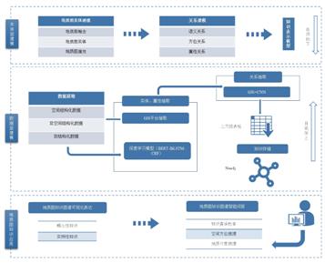
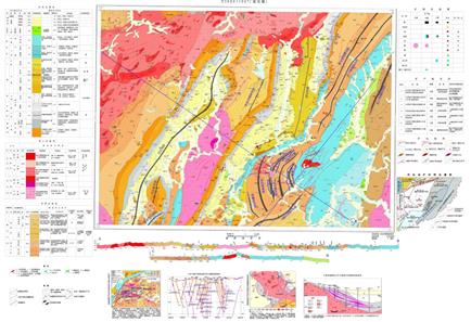
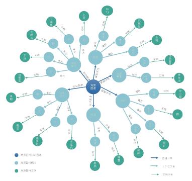
海量地质图件蕴含着丰富的地学基础知识及专家经验知识。地质图主要表达了通过区域地质调查、矿产地质调查所获取的地球表面的地质知识(如地层单元、岩体、断裂等)。如何快速地从矢量地质图件中抽取地质知识并形成知识服务是目前地学知识图谱及知识服务研究的前沿。由于传统的地质图知识抽取主要依赖人工方式进行综合分析,本文聚焦于矢量地质图件知识表达与抽取研究,提出了一种地质图知识表达框架,提取地质图中所包含的地质实体及关系,将地质图信息以知识图谱的形式表达,并开展了基于地质矢量知识图谱的智能问答应用。最后以江西省于都县银坑幅矢量数据集为例开展实验验证分析,结果表明,本文方法能够较为全面地获取地质图中各个地质对象的信息,提高了地质图语义表达的效果,同时也可以提高地质学习人员对地质图的理解和认识,让计算机能够大规模获取地质图的知识内容。


关 键 词:地质图知识表达模型   地质知识图谱   地质矢量图件   智能问答   空间认知
收稿时间:2023-08-19
修稿时间:2023-12-02

Geological map-oriented knowledge graph construction and intelligent Q&A application
Duan Yuxi, Qiu Qinjun, Tian Miao, Ma Kai, Xie Zhong, Tao Liufeng, Liu Junjie. 2024. Geological map-oriented knowledge graph construction and intelligent Q&A application. Chinese Journal of Geology, 59(2): 588-602. doi: 10.12017/dzkx.2024.041
Authors:Duan Yuxi  Qiu Qinjun  Tian Miao  Ma Kai  Xie Zhong  Tao Liufeng  Liu Junjie
Affiliation:1. National Engineering Research Center of Geographic Information System, Wuhan 430074; 2. School of Computer Science, China University of Geosciences, Wuhan 430074; 3. National Engineering Research Center of Geographic Information System, Wuhan 430074; 4. Key Laboratory of Geological Survey and Evaluation of Ministry of Education, China University of Geosciences, Wuhan 430074; 5. College of Computer and Information Technology, China Three Gorges University, Yichang, Hubei 443002; 6. Hubei Key Laboratory of Intelligent Vision Based Monitoring for Hydroelectric Engineering, China Three Gorges University, Yichang, Hubei 443002
Abstract:Massive geological maps contain rich basic knowledge of geology and expert experience knowledge. Geological maps mainly express geological knowledge of the Earth's surface(e.g., stratigraphic units, rock bodies, fractures, etc.)acquired through regional geological surveys and mineral geological surveys. How to quickly extract geological knowledge from vector geological maps and form knowledge services is currently the forefront of research on geoscientific knowledge graph and knowledge services. Traditional geological map knowledge extraction mainly relies on manual methods for comprehensive analysis. This paper focuses on the research of knowledge expression and extraction of vector geological map, proposes a geological map knowledge expression framework, extracts geological entities and relationships contained in geological maps, expresses geological map information in the form of knowledge graph, and carries out intelligent question and answer applications based on geological vector knowledge map. Based on the experimental validation analysis of the vector dataset of Yinkeng Formation in Yudu County, Jiangxi Province. Finally, the experimental validation analysis is carried out with the vector data set of Yinkeng in Yudu County, Jiangxi Province, and the results show that the method of this paper can obtain the information of each geological object in geological maps in a more comprehensive way, improve the effect of semantic expression of geological maps, and at the same time improve the understanding and knowledge of geological learners about geological maps, so that computers can obtain the knowledge content of geological maps on a large scale.
Keywords:Geological map knowledge expression model  Geological knowledge graph  Geological vector map  Intelligent question and answer  Spatial cognition
点击此处可从《地质科学》浏览原始摘要信息
点击此处可从《地质科学》下载全文
设为首页 | 免责声明 | 关于勤云 | 加入收藏

Copyright©北京勤云科技发展有限公司  京ICP备09084417号