Topography of mantle transition zone discontinuities beneath Northeast China imaged by receiver function with Ps scattering kernel
-
摘要:
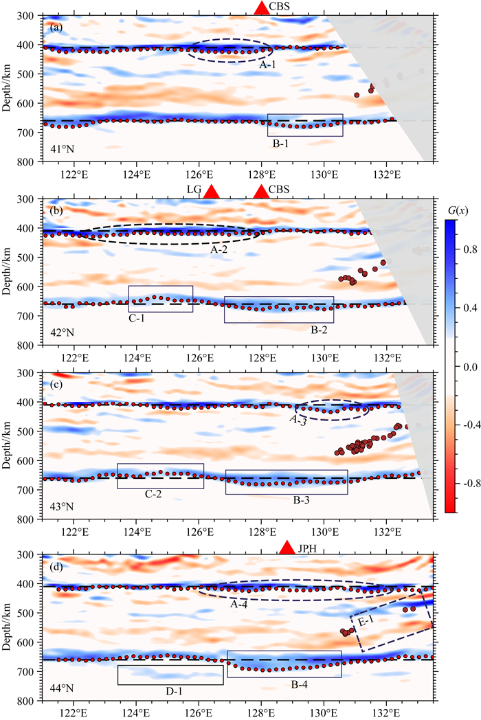
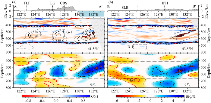
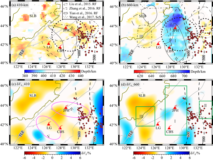
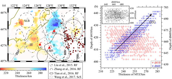
地幔转换带是上下地幔物质运移和能量交换的必经通道,其速度结构和上下界面的起伏能够为认识地幔内部的温度和物质变化、地幔对流模式等地球演化相关的科学问题提供关键约束.本文利用布设在中国东北地区的高密度固定台网和流动台阵所记录的远震体波接收函数,采用Ps散射核叠前深度偏移成像方法,获得了台站下方地幔转换带界面及其内部速度间断面的三维精细图像.研究结果表明:西北太平洋俯冲板片上下界面在地幔转换带内清晰可见,在高纬度(44°N)区域存在约30°的倾角;660-km间断面的深度起伏具有明显的分区性,在与俯冲板片相交处以西200~300 km,界面出现约20~40 km的下沉,而长白山和龙岗火山的西北区域存在约5~15 km的抬升,分别与板片滞留引起的低温异常和局部热物质上涌相对应;410-km间断面的起伏形态较复杂,在大部分区域观测到大于10 km的下沉,且表现出明显的区域性横向变化,与深俯冲动力学背景下冷的温度异常造成的影响不一致.我们认为板片俯冲、停滞和海沟后撤过程中引起的地幔转换带物质异常、含水状态及分布的变化是显著改变410-km间断面形态的主要原因.本文获得的高精度地幔转换带界面三维形态为更好地认识东北亚地区俯冲板片在地幔物质分布和能量交换中的作用提供了重要参考.
Abstract:Mantle transition zone connects Earth's upper and lower mantle and holds key information on the compositional and thermal states at depths. The depth variation,i.e. topography,of mantle transition zone discontinuities implies regional changes of temperature and/or composition because of their well-established relationship to the solid phase transitions between high-pressure polymorphs of olivine. Based on the teleseismic receiver functions collected from densely deployed permanent network and two temporary arrays in Northeast China,we imaged the transition zone structures using Ps scattering kernel. The results show clear boundaries of the Northwest Pacific slab at the transition zone depth,with a dip angle of about 30°. We observed 20~40 km depression of the 660-km discontinuity near where prior tomographic studies suggested subducted slab. Such depression may be explained by the lower mantle temperature caused by the cold Pacific plate. Beneath the northwest of Changbaishan and Longgang Volcano,the 660-km discontinuity is elevated by 5~15 km,indicating high temperature anomalies that may come from upwelling. In contrast,the topography of the 410-km discontinuity reveals a widely spreading 10 km depression in most areas,and it shows obvious regional lateral variation. Such large-scale depression suggests that compositional changes introduced from subduction,such as basalt fraction and water content,also play a role in controlling the 410-km discontinuity topography. The high-resolution three-dimensional topography of the mantle transition zone obtained in this study will motivate further investigations on understanding the transformation of mantle material distribution and energy exchange by subduction plates in Northeast Asia.
-

-
-
Ai Y S, Zheng T Y, Xu W W, et al. 2003. A complex 660 km discontinuity beneath northeast China. Earth and Planetary Science Letters, 212(1-2): 63-71, doi:10.1016/s0012-821x(03)00266-8.
Bercovici D, Karato S I. 2003. Whole-mantle convection and the transition-zone water filter. Nature, 425(6953): 39-44, doi:10.1038/nature01918.
Bina C R, Helffrich G. 1994. Phase transition Clapeyron slopes and transition zone seismic discontinuity topography. Journal of Geophysical Research: Solid Earth, 99(B8): 15853-15860, doi:10.1029/94JB00462.
Bolfan-Casanova N, Keppler H, Rubie D C. 2000. Water partitioning between nominally anhydrous minerals in the MgO-SiO2-H2O system up to 24 GPa: Implications for the distribution of water in the Earth's mantle. Earth and Planetary Science Letters, 182(3-4): 209-221, doi:10.1016/S0012-821X(00)00244-2.
Bostock M G, Rondenay S, Shragge J. 2001. Multiparameter two-dimensional inversion of scattered teleseismic body waves 1. Theory for oblique incidence. Journal of Geophysical Research: Solid Earth, 106(B12): 30771-30782, doi:10.1029/2001JB000330.
Bostock M G. 2007. Theory and observations-teleseismic body-wave scattering and receiver-side structure. Treatise on Geophysics, 1: 219-246, doi:10.1016/B978-044452748-6.00008-0.
Cammarano F, Goes S, Vacher P, et al. 2003. Inferring upper-mantle temperatures from seismic velocities. Physics of the Earth and Planetary Interiors, 138(3-4): 197-222, doi:10.1016/S0031-9201(03)00156-0.
Chen C X, Zhao D P, Tian Y, et al. 2017. Mantle transition zone, stagnant slab and intraplate volcanism in Northeast Asia. Geophysical Journal International, 209(1): 68-65, doi:10.1093/gji/ggw491.
Chen J H, Liu H Z, Girard J. 2011. Comparative in situ X-ray diffraction study of San Carlos olivine: Influence of water on the 410 km seismic velocity jump in Earth's mantle. American Mineralogist, 96(5-6): 697-702, doi:10.2138/am.2011.3602.
Chen L, Wen L X, Zheng T Y. 2005. A wave equation migration method for receiver function imaging: 1. Theory. Journal of Geophysical Research: Solid Earth, 110(B11): B11309, doi:10.1029/2005JB003665.
Chen M, Tromp J, Helmberger D, et al. 2007. Waveform modeling of the slab beneath Japan. Journal of Geophysical Research: Solid Earth, 112(B2): B02305, doi:10.1029/2006JB004394.
Chen Q F, Ai Y S, Chen Y. 2019. Overview of deep structures under the Changbaishan volcanic area in Northeast China. Science China Earth Sciences, 62(6): 935-952, doi:10.1007/s11430-018-9300-1.
Cheng C, Bodin T, Allen R M. 2016. Three-dimensional pre-stack depth migration of receiver functions with the fast marching method: a Kirchhoff approach. Geophysical Journal International, 205(2): 819-829, doi:10.1093/gji/ggw062.
Courtier A M, Revenaugh J. 2007. Deep upper-mantle melting beneath the Tasman and Coral Seas detected with multiple ScS reverberations. Earth and Planetary Science Letters, 259(1-2): 66-76, doi:10.1016/j.epsl.2007.04.027.
Dahlen F A, Hung S H, Nolet G. 2000. Frechet kernels for finite-frequency traveltimes-I. Theory. Geophysical Journal International, 141(1): 157-174, doi:10.1046/j.1365-246X.2000.00070.x.
DeKool M, Rawlinson N, Sambridge M. 2006. A practical grid-based method for tracking multiple refraction and reflection phases in three-dimensional heterogeneous media. Geophysical Journal International, 167(1): 253-270, doi:10.1111/j.1365-246X.2006.03078.x.
Deuss A, Redfern S A T, Chambers K, et al. 2006. The nature of the 660-kilometer discontinuity in Earth's mantle from global seismic observations of PP precursors. Science, 311(5758): 198-201, doi:10.1126/science.1120020.
Dokht R M H, Gu Y J, Sacchi M D. 2016. Waveform inversion of SS precursors: An investigation of the northwestern Pacific subduction zones and intraplate volcanoes in China. Gondwana Research, 40: 77-90, doi:10.1016/j.gr.2016.07.006.
Dziewonski A M, Anderson D L. 1981. Preliminary reference Earth model. Physics of the Earth and Planetary Interiors, 25(4): 297-356, doi:10.1016/0031-9201(81)90046-7.
Fei Y W, Bertka C M. 1999. Phase transitions in the Earth's mantle and mantle mineralogy. //Fei Y W, Bertka C M, Mysen B O eds. Mantle Petrology: Field Observations and High Pressure Experimentation: A Tribute to Francis R. (Joe) Boyd. The Geochemical Society Special Publication, (6): 189-207.
Fei Y W, Van Orman J, Li J, et al. 2004. Experimentally determined postspinel transformation boundary in Mg2SiO4 using MgO as an internal pressure standard and its geophysical implications. Journal of Geophysical Research: Solid Earth, 109(B2): B02305, doi:10.1029/2003JB002562.
Flanagan M P, Shearer P M. 1998. Global mapping of topography on transition zone velocity discontinuities by stacking SS precursors. Journal of Geophysical Research: Solid Earth, 103(B2): 2673-2692, doi:10.1029/97jb03212.
Fukao Y, Obayashi M. 2013. Subducted slabs stagnant above, penetrating through, and trapped below the 660 km discontinuity. Journal of Geophysical Research: Solid Earth, 118(11): 5920-5938, doi:10.1002/2013jb010466.
Han G J, Li J, Guo G R, et al. 2021. Pervasive low-velocity layer atop the 410-km discontinuity beneath the northwest Pacific subduction zone: Implications for rheology and geodynamics. Earth and Planetary Science Letters, 554: 116642, doi:10.1016/j.epsl.2020.116642.
Hao S Q, Wang W Z, Qian W S, et al. 2019. Elasticity of akimotoite under the mantle conditions: Implications for multiple discontinuities and seismic anisotropies at the depth of ~600-750 km in subduction zones. Earth and Planetary Science Letters, 528: 115830, doi:10.1016/j.epsl.2019.115830.
Helffrich G R, Wood B J. 2001. The Earth's mantle. Nature, 412(6846): 501-507, doi:10.1038/35087500.
Hirose K, Kawamoto T. 1995. Hydrous partial melting of lherzolite at 1 GPa: the effect of H2O on the genesis of basaltic magmas. Earth and Planetary Science Letters, 133(3-4): 463-473, doi:10.1016/0012-821X(95)00096-U.
Hirose K. 2002. Phase transitions in pyrolitic mantle around 670-km depth: Implications for upwelling of plumes from the lower mantle. Journal of Geophysical Research: Solid Earth, 107(B4): ECV 3-1-ECV 3-13, doi:10.1029/2001JB000597.
Huang J L, Zhao D P. 2006. High-resolution mantle tomography of China and surrounding regions. Journal of Geophysical Research: Solid Earth, 111(B9): B09305, doi:10.1029/2005JB004066.
Huang X G, Xu Y S, Karato S I. 2005. Water content in the transition zone from electrical conductivity of wadsleyite and ringwoodite. Nature, 434(7034): 746-749, doi:10.1038/nature03426.
Irifune T, Isshiki M. 1998. Iron partitioning in a pyrolite mantle and the nature of the 410-km seismic discontinuity. Nature, 392(6677): 702-705, doi:10.1038/33663.
Ito E, Akaogi M, Topor L, et al. 1990. Negative pressure-temperature slopes for reactions formign MgSiO3 perovskite from calorimetry. Science, 249(4974): 1275-1278, doi:10.1126/science.249.4974.1275.
Karato S I, Bercovici D, Leahy G, et al. 2006. The transition-zone water filter model for global material circulation: where do we stand?//Jacobsen S D, Lee S V D eds. Earth's Deep Water Cycle. American Geophysical Union, Washington, D.C. : 289-313, doi: 10.1029/168GM22.
Katsura T, Ito E. 1989. The system Mg2SiO4-Fe2SiO4 at high pressures and temperatures: Precise determination of stabilities of olivine, modified spinel, and spinel. Journal of Geophysical Research: Solid Earth, 94(B11): 15663-15670, doi:10.1029/JB094iB11p15663.
Katsura T, Yamada H, Nishikawa O, et al. 2004. Olivine-wadsleyite transition in the system (Mg, Fe)2SiO4. Journal of Geophysical Research: Solid Earth, 109(B2): B02209, doi:10.1029/2003JB002438.
Kennett B L N, Engdahl E R, Buland R. 1995. Constraints on seismic velocities in the Earth from traveltimes. Geophysical Journal International, 122(1): 108-124, doi:10.1111/j.1365-246X.1995.tb03540.x.
Kohlstedt D L, Keppler H, Rubie D C. 1996. Solubility of water in the α, β and γ phases of (Mg, Fe)2SiO4. Contributions to Mineralogy and Petrology, 123(4): 345-357, doi:10.1007/s004100050161.
Kuritani T, Ohtani E, Kimura J I. 2011. Intensive hydration of the mantle transition zone beneath China caused by ancient slab stagnation. Nature Geoscience, 4(10): 713-716, doi:10.1038/ngeo1250.
Lai Y J, Chen L, Wang T, et al. 2019. Mantle transition zone structure beneath northeast Asia from 2-D triplicated waveform modeling: implication for a segmented stagnant slab. Journal of Geophysical Research: Solid Earth, 124(2): 1871-1888, doi:10.1029/2018jb016642.
Langston C A. 1979. Structure under Mount Rainier, Washington, inferred from teleseismic body waves. Journal of Geophysical Research: Solid Earth, 84(B9): 4749-4762, doi:10.1029/JB084iB09p04749.
Lei J S, Zhao D P, Xu Y G, et al. 2018. Is there a gap in the stagnant Pacific slab in the mantle transition zone under the Changbaishan volcano? Acta Petrologica Sinica (in Chinese), 34(1): 13-22. http://en.cnki.com.cn/Article_en/CJFDTotal-YSXB201801003.htm
Levander A, Miller M S. 2012. Evolutionary aspects of lithosphere discontinuity structure in the western U.S. Geochemistry, Geophysics, Geosystems, 13(7): Q0AK07, doi:10.1029/2012GC004056.
Li D Z, Helmberger D, Clayton R W, et al. 2014. Global synthetic seismograms using a 2-D finite-difference method. Geophysical Journal International, 197(2): 1166-1183, doi:10.1093/gji/ggu050.
Li J, Chen Q F, Vanacore E, et al. 2008. Topography of the 660-km discontinuity beneath northeast China: Implications for a retrograde motion of the subducting Pacific slab. Geophysical Research Letters, 35, L01302, doi:10.1029/2007GL031658.
Li J, Wang X, Wang X J, et al. 2013. P and SH velocity structure in the upper mantle beneath Northeast China: Evidence for a stagnant slab in hydrous mantle transition zone. Earth and Planetary Science Letters, 367: 71-81, doi:10.1016/j.epsl.2013.02.026.
Li J, Yuen D A. 2014. Mid-mantle heterogeneities associated with Izanagi plate: Implications for regional mantle viscosity. Earth and Planetary Science Letters, 385: 137-144, doi:10.1016/j.epsl.2013.10.042.
Li J H, Shen Y, Zhang W. 2018. Three-dimensional passive-source reverse-time migration of converted waves: the method. Journal of Geophysical Research: Solid Earth, 123(2): 1419-1434, doi:10.1002/2017jb014817.
Li S W, Weng A H, Li J P, et al. 2020. Deep origin of Cenozoic volcanoes in Northeast China revealed by 3-D electrical structure. Science China Earth Sciences, 63(4): 533-547, doi:10.1007/s11430-018-9537-2.
Li X Q, Yuan X H. 2003. Receiver functions in northeast China-implications for slab penetration into the lower mantle in northwest Pacific subduction zone. Earth and Planetary Science Letters, 216(4): 679-691, doi:10.1016/s0012-821x(03)00555-7.
Liu K J, Levander A. 2013. Three-dimensional Kirchhoff-approximate generalized Radon transform imaging using teleseismic P-to-S scattered waves. Geophysical Journal International, 192(3): 1196-1216, doi:10.1093/gji/ggs073.
Liu X, Zhao D P, Li S Z, et al. 2017. Age of the subducting pacific slab beneath East Asia and its geodynamic implications. Earth and Planetary Science Letters, 464: 166-174. doi:10.1016/j.epsl.2017.02.024.
Liu Z, Niu F L, Chen Y J, et al. 2015. Receiver function images of the mantle transition zone beneath NE China: New constraints on intraplate volcanism, deep subduction and their potential link. Earth and Planetary Science Letters, 412: 101-111, doi:10.1016/j.epsl.2014.12.019.
Maguire R, Ritsema J, Goes S. 2018. Evidence of subduction-related thermal and compositional heterogeneity below the United States from transition zone receiver functions. Geophysical Research Letters, 45(17): 8913-8922, doi:10.1029/2018GL078378.
Mao Z, Jacobsen S D, Frost D J, et al. 2011. Effect of hydration on the single-crystal elasticity of Fe-bearing wadsleyite to 12 GPa. American Mineralogist, 96(10): 1606-1612, doi:10.2138/am.2011.3807.
Mao Z, Li X Y. 2016. Effect of hydration on the elasticity of mantle minerals and its geophysical implications. Science China Earth Sciences, 59(5): 873-888, doi:10.1007/s11430-016-5277-9.
Meijde M V D, Marone F, Giardini D, et al. 2003. Seismic evidence for water deep in Earth's upper mantle. Science, 300(5625): 1556-1558, doi:10.1126/science.1083636.
Niu F L, Kawakatsu H. 1996. Complex structure of mantle discontinuities at the tip of the subducting slab beneath Northeast China. A preliminary investigation of broadband receiver functions. Journal of Physics of the Earth, 44(6): 701-711, doi:10.4294/jpe1952.44.701.
Niu F L, Li J. 2011. Component azimuths of the CEArray stations estimated from P-wave particle motion. Earthquake Science, 24(1): 3-13, doi:10.1007/s11589-011-0764-8.
Obayashi M, Yoshimitsu J, Fukao Y. 2009. Tearing of stagnant slab. Science, 324(5931): 1173-1175, doi:10.1126/science.1172496.
Pan J T, Wu Q J, Li Y H, et al. 2014. Ambient noise tomography in northeast China. Chinese Journal of Geophysics (in Chinese), 57(3): 812-821, doi:10.6038/cjg20140311.
Rawlinson N, Sambridge M. 2004. Wave front evolution in strongly heterogeneous layered media using the fast marching method. Geophysical Journal International, 156(3): 631-647, doi:10.1111/j.1365-246X.2004.02153.x.
Rondenay S. 2009. Upper mantle imaging with array recordings of converted and scattered teleseismic waves. Surveys in Geophysics, 30(4-5): 377-405, doi:10.1007/s10712-009-9071-5.
Sakamaki T, Suzuki A, Ohtani E. 2006. Stability of hydrous melt at the base of the Earth's upper mantle. Nature, 439(7073): 192-194, doi:10.1038/nature04352.
Schmerr N, Garnero E J. 2007. Upper mantle discontinuity topography from thermal and chemical heterogeneity. Science, 318(5850): 623-626, doi:10.1126/science.1145962.
Schmerr N, Thomas C. 2011. Subducted lithosphere beneath the Kuriles from migration of PP precursors. Earth and Planetary Science Letters, 311(1-2): 101-111, doi:10.1016/j.epsl.2011.09.002.
Sheng J, Liao J, Gerya T. 2016. Numerical modeling of deep oceanic slab dehydration: Implications for the possible origin of far field intra-continental volcanoes in northeastern China. Journal of Asian Earth Sciences, 117: 328-336, doi:10.1016/j.jseaes.2015.12.022.
Steckler M S, Agostinetti N P, Wilson C K, et al. 2008. Crustal structure in the Southern Apennines from teleseismic receiver functions. Geology, 36(2): 155-158, doi:10.1130/G24065A.1.
Sun M C, Fu X F, Liu K H, et al. 2018. Absence of thermal influence from the African Superswell and cratonic keels on the mantle transition zone beneath southern Africa: Evidence from receiver function imaging. Earth and Planetary Science Letters, 503: 108-117, doi:10.1016/j.epsl.2018.09.012.
Sun M C, Gao S S, Liu K H, et al. 2020. Upper mantle and mantle transition zone thermal and water content anomalies beneath NE Asia: Constraints from receiver function imaging of the 410 and 660 km discontinuities. Earth and Planetary Science Letters, 532: 116040, doi:10.1016/j.epsl.2019.116040.
Sun Y Z, Hier-Majumder S, Xu Y G, et al. 2021. Walter Stability and migration of slab-derived carbonate-rich melts above the transition zone. Earth and Planetary Science Letters, 531: 116000, doi:10.1016/j.epsl.2019.116000.
Takeuchi N, Kawakatsu H, Tanaka S, et al. 2014. Upper mantle tomography in the northwestern Pacific region using triplicated P waves. Journal of Geophysical Research: Solid Earth, 119(10): 7667-7685, doi:10.1002/2014jb011161.
Tang Y C, Obayashi M, Niu F L, et al. 2014. Changbaishan volcanism in northeast China linked to subduction-induced mantle upwelling. Nature Geoscience, 7(6): 470-475, doi:10.1038/ngeo2166.
Tao K, Niu F L, Ning J Y, et al. 2014. Crustal structure beneath NE China imaged by NECESSArray receiver function data. Earth and Planetary Science Letters, 398: 48-57, doi:10.1016/j.epsl.2014.04.043.
Tao K, Grand S P, Niu F L. 2018. Seismic structure of the upper mantle beneath eastern Asia from full waveform seismic tomography. Geochemistry, Geophysics, Geosystems, 19(8): 2732-2763, doi:10.1029/2018gc007460.
Tauzin B, Van Der Hilst R D, Wittlinger G, et al. 2013. Multiple transition zone seismic discontinuities and low velocity layers below western United States. Journal of Geophysical Research: Solid Earth, 118(5): 2307-2322, doi:10.1002/jgrb.50182.
Tian Y, Zhu H X, Zhao D P, et al. 2016. Mantle transition zone structure beneath the Changbai volcano: Insight into deep slab dehydration and hot upwelling near the 410 km discontinuity. Journal of Geophysical Research: Solid Earth, 121(8): 5794-5808, doi:10.1002/2016jb012959.
Tselentis G A. 1990. Interstation surface wave attenuation by autoregressive deconvolution. Pure and Applied Geophysics, 133(3): 429-446, doi:10.1007/BF00877999.
Vacher P, Mocquet A, Sotin C. 1998. Computation of seismic profiles from mineral physics: the importance of the non-olivine components for explaining the 660 km depth discontinuity. Physics of the Earth and Planetary Interiors, 106(3-4): 275-298, doi:10.1016/S0031-9201(98)00076-4.
Wang B S, Niu F L. 2010. A broad 660 km discontinuity beneath northeast China revealed by dense regional seismic networks in China. Journal of Geophysical Research: Solid Earth, 115(B6): B06308, doi:10.1029/2009jb006608.
Wang X, Chen Q F, Li J, et al. 2016. Seismic sensor misorientation measurement using P-wave particle motion: an application to the NECsaids array. Seismological Research Letters, 87(4): 901-911, doi:10.1785/0220160005.
Wang X, Li J, Chen Q F. 2017. Topography of the 410 km and 660 km discontinuities beneath the Japan Sea and adjacent regions by analysis of multiple-ScS waves. Journal of Geophysical Research: Solid Earth, 122(2): 1264-1283, doi:10.1002/2016jb013357.
Wang X, Chen Q F, Niu F L, et al. 2020. Distinct slab interfaces imaged within the mantle transition zone. Nature Geoscience, 13(12): 822-827, doi:10.1038/s41561-020-00653-5.
Wu Q J, Li Y H, Zhang R Q, et al. 2007. Receiver functions from autoregressive deconvolution. Pure and Applied Geophysics, 164(11): 2175-2192, doi:10.1007/s00024-007-0269-5.
Xie J, Chu R S, Ni S D. 2021. Evaluating global tomography models with antipodal ambient noise cross-correlation functions. Journal of Geophysical Research: Solid Earth, 126(3): e2020JB020444, doi:10.1029/2020jb020444.
Yang J F, Faccenda M. 2020. Intraplate volcanism originating from upwelling hydrous mantle transition zone. Nature, 579(7797): 88-91, doi:10.1038/s41586-020-2045-y.
Zhang F X, Wu Q J. 2019. Velocity structure in upper mantle and its implications for the volcanism nearby the north edge of Songliao Basin. Chinese Journal of Geophysics (in Chinese), 62(8): 2918-2929, doi:10.6038/cjg2019M0665.
Zhang H, Schmandt B. 2019. Application of Ps scattering kernels toimaging the mantle transition zone with receiver functions. Journal of Geophysical Research: Solid Earth, 124(1): 709-728, doi:10.1029/2018jb016274.
Zhang L M, Li J, Wang T, et al. 2020. Body waves retrieved from noise cross-correlation reveal lower mantle scatterers beneath the Northwest Pacific subduction zone. Geophysical Research Letters, 47(19): e2020GL088846, doi:10.1029/2020gl088846.
Zhang R Q, Gao Z Y, Wu Q J, et al. 2016. Seismic images of the mantle transition zone beneath Northeast China and the Sino-Korean craton from P-wave receiver functions. Tectonophysics, 675: 159-167, doi:10.1016/j.tecto.2016.03.002.
Zheng X F, Ou Y B, Zhang D N, et al. 2009. Technical system construction of Data Backup Centre for China seismograph network and the data support to researches on the Wenchuan earthquake. Chinese Journal of Geophysics (in Chinese), 52(5): 1412-1417, doi:10.3969/j.issn.0001-5733.2009.05.031.
Zhou C Y, Jin Z M, Zhang J F. 2010. Mantle transition zone: An important field in the studies of Earth's deep interior. Earth Science Frontiers (in Chinese), 17(3): 90-113. http://en.cnki.com.cn/Article_en/CJFDTotal-DXQY201003010.htm
Zhu L P. 2000. Crustal structure across the San Andreas Fault, southern California from teleseismic converted waves. Earth and Planetary Science Letters, 179(1): 183-190, doi:10.1016/S0012-821X(00)00101-1.
陈棋福, 艾印双, 陈赟. 2019. 长白山火山区深部结构探测的研究进展与展望. 中国科学: 地球科学, 49(5): 778-795, doi:10.1360/n072018-00040.
雷建设, 赵大鹏, 徐义刚等. 2018. 长白山火山下方地幔转换带中滞留的俯冲太平洋板块存在空缺吗? 岩石学报, 34(1): 13-22. https://www.cnki.com.cn/Article/CJFDTOTAL-YSXB201801003.htm
李世文, 翁爱华, 李建平等. 2020. 三维电性结构揭示的中国东北地区新生代火山深部起源. 中国科学: 地球科学, 50(4): 538-552, doi:10.1360/n072018-00330.
毛竹, 李新阳. 2016. 水对地幔矿物弹性性质的影响及其地球物理意义. 中国科学: 地球科学, 46(4): 411-429, doi:10.1360/N072015-00365.
潘佳铁, 吴庆举, 李永华等. 2014. 中国东北地区噪声层析成像. 地球物理学报, (3): 812-821, doi:10.6038/cjg20140311. http://www.geophy.cn//CN/abstract/abstract10217.shtml
张风雪, 吴庆举. 2019. 松辽盆地北缘的上地幔速度结构及该区火山成因探讨. 地球物理学报, 62(8): 2918-2929, doi:10.6038/cjg2019M0665. http://www.geophy.cn//CN/abstract/abstract15115.shtml
郑秀芬, 欧阳飚, 张东宁等. 2009. "国家数字测震台网数据备份中心"技术系统建设及其对汶川大地震研究的数据支撑. 地球物理学报, 52(5): 1412-1417, doi:10.3969/j.issn.0001-5733.2009.05.031. http://www.geophy.cn//CN/abstract/abstract1034.shtml
周春银, 金振民, 章军锋. 2010. 地幔转换带: 地球深部研究的重要方向. 地学前缘, 17(3): 90-113. https://www.cnki.com.cn/Article/CJFDTOTAL-DXQY201003010.htm
-


 下载:
下载:

