
Optically stimulated luminescence dating of paleoshorelines revealed Late Quaternary lake evolution in Alxa Plateau
-
摘要:
阿拉善高原位于现代西风环流与东亚季风环流过渡带,该地区分布的湖泊对全球性气候变化响应极为敏感,阿拉善高原广泛分布的古湖岸堤为较准确地重建晚第四纪湖泊水位变化提供了良好载体。近年对黑河、石羊河尾闾湖泊以及吉兰泰盐池、雅布赖盆地等地的古湖岸堤的沉积地层以及石英和钾长石释光测年研究,重建了不同区域较高分辨率的末次间冰期以来湖泊时空演化过程。发现早在300 ka以前阿拉善高原就已经形成了高水位湖泊,黑河尾闾额济纳盆地在MIS 11或更早、MIS 9、MIS 7、MIS 5和MIS 1形成了高湖面湖泊,高湖面湖泊形成存在100 ka的周期。阿拉善高原在末次间冰期及全新世形成了稳定高湖面湖泊,但间冰期内部湖面波动具有空间差异性,东部区域湖泊高湖面出现在MIS 5e~5c和中全新世,西部湖泊高湖面出现在MIS 5a~5c和晚全新世。湖面变化的空间差异性很可能与冰期-间冰期旋回尺度及间冰期内部东亚夏季风与西风气候系统在阿拉善高原的相互作用密切相关。
Abstract:The arid Alxa Plateau (37°~42°N, 99°107°E) is located at a major climatic transition zone between the East Asian Summer Monsoon (EASM) and the Westerlies. Endorheic rivers terminating in closed lake systems in this region are sensitive to changes in the EASM and westerlies. Well-preserved palaeoshorelines provide a record of lake-level change during the Late Quaternary. Quartz-OSL and post-IR IRSL (pIRIR) luminescence methods have been systematically applied to survey (using d-GPS) palaeoshorelines preserved in the terminal-lake systems of the Heihe River, Shiyang River, Jilantai Salt Lake and the Yabulai Basin to derive chronologies of lake evolution. The earliest shorelines are preserved in the Ejina Basin (> 300 ka). A systematic relation between glacial-interglacial cycles and lake highstands (MIS 9, 7, 5, 1) in Ejina Basin has been identified, attesting to the impact of orbital forcing on the EASM/Westerlies precipitation and lake level changes in Alxa Plateau. However, spatio-temporal variations in lake level changes are indicated in different regions of the Alxa Plateau:(1) Eastern part of the plateau sustained lake highstands during MIS 5e~5c and the mid-Holocene; whereas (2) the western part of the plateau sustained lake highstands during MIS 5c~5a and the Late Holocene. The complex interactions between the East Asian summer monsoon and the Westerlies on glacial-interglacial cycles and inside interglacial is likely responsible for spatial difference of lake level changes inside interglacial at Alxa Plateau.
-
Key words:
- Alxa Plateau /
- palaeolake shorelines /
- luminescence dating /
- lake evolution /
- last interglacial /
- the Holocene
-

-
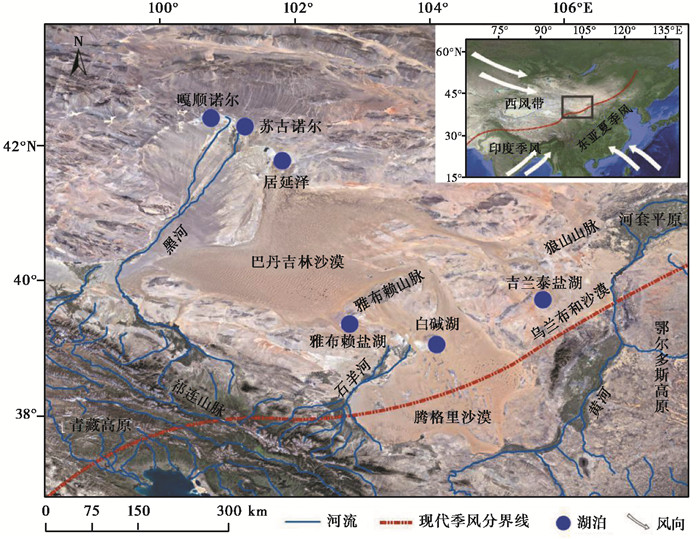
图 1
阿拉善高原遥感影像及已有主要研究点分布图
Figure 1.
Map showing the locations of the Alxa Plateau(AP)and the studied shoreline sections
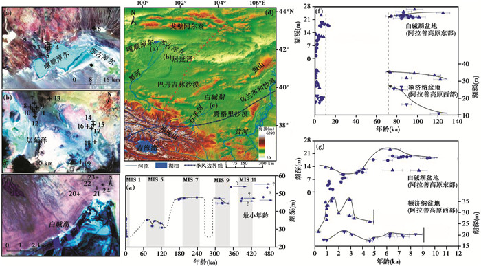
图 2
阿拉善高原黑河及白碱湖尾闾湖泊晚第四纪湖面变化及间冰期内部湖面变化的空间差异性(依据Li等[49~50]改绘)
Figure 2.
The reconstructed lake level changes during Late Quaternary and spatial variation during insides interglacial in the terminal-lake basin of Heihe River and Shiyang River of Alxa Plateau, modified from Li et al. [49~50]. (a) and (b) are distribution of paleolake shorelines at Gaxun Nur-Sogu Nur Basin[48] and Juyanze Basin[47, 51], respectively. (c) is distribution of paleolake shorelines at Baijian Lake Basin[35, 50]. (d) is the map of study area, the blue dotted line is the boundary of modern East Asia summer monsoon[52] and red dash line is the boundary of possible maximum EASM precipitation dominance at study area[50]. (e) is the reconstructed lake level changes in Ejina Basin on glacial-interglacial cycles[49]. (f) and (g) are the reconstructed lake level changes at Alexa Plateau since last interglacial and during Holocene, respectively[50], and the cycles age data used in the fig are cited from Long et al. [35]
表 1
阿拉善高原古湖岸堤探槽剖面信息
Table 1.
The summary of paleolake shoreline sections in Alxa Plateau
序号 剖面 纬度(N) 经度(E) 海拔(m) 对应水深(m) 湖岸堤海拔(m) 剖面深度(m) 湖盆 1 GXNT-1 42°27′30.73″ 100°35′33.19″ 902.5 8 903 2.5 嘎顺诺尔-苏古诺尔[48] 2 GXNT-2 42°27′29.45″ 100°35′16.41″ 910.1 16 910 4.0 3 GXNT-3 42°27′30.78″ 100°35′07.96″ 911.4 17 911 4.6 4 GXNT-4 42°29′01.84″ 100°35′44.94″ 913.4 19 913 4.0 5 GXNT-5 42°29′01.28″ 100°35′40.46″ 914.8 20 915 6.4 6 GXNT-6 42°32′36.10″ 100°51′47.85″ 919.1 25 919 5.0 7 WT-4 41°54′15.66″ 101°45′25.17″ 920.7 20 920 1.5 西居延泽[50~51] 8 WT-2 41°54′18.22″ 101°45′15.32″ 917.6 14 914 1.5 9 WT-1 41°54′19.03″ 101°45′0.02″ 912.0 12 912 1.2 10 JYZXT-2 41°54′18″ 101°45′40.1″ 926.9 27 927 4.0 11 JYZXT-1 41°54′26.1″ 101°45′1″ 914.0 14 914 2.8 12 ET-11 41°54′07″ 101°45′28″ 944.3 44 944 10.0 东居延泽[47, 49, 51] 13 ET-8 41°56′22.87″ 101°48′47.08″ 939.9 40 940 9.0 14 ET-7 41°51′16.37″ 101°58′07.93″ 927.1 27 927 6.1 15 ET-6 41°51′15.76″ 101°58′05.28″ 926.4 26 927 1.7 16 ET-5 41°51′18.71″ 101°57′51.87″ 923.9 24 924 5.5 17 ET-2 41°51′23.50″ 101°57′0.13″ 917.7 18 918 4.1 18 ET-9 41°49′25.98″ 101°58′34.44″ 939.6 40 940 9.0 19 ET-10 41°44′42″ 101°54′24″ 944.0 44 944 1.0 20 BJHT-1 39°09′41.7″ 104°09′35.2″ 1303.0 11 1303 4.7 白碱湖[35, 50] 21 BJHT-3 39°09′59.7″ 104°09′26.8″ 1317.0 25 1317 2.4 22 BJHT-2 39°09′52.7″ 104°09′32.8″ 1314.0 22 1314 1.8 23 BJ-S1 39°08′46″ 104°08′57″ 1314.0 22 1314 2.5 24 BJ-S2 39°08′42″ 104°08′01″ 1307.0 15 1307 2.5  下载: 导出CSV
表 2
阿拉善高原古湖岸堤剖面石英OSL年龄与钾长石pIRIR年龄结果
Table 2.
Summary of quartz OSL and K-feldspar pIRIR ages of samples from paleolake shorelines at Alxa Plateau
嘎顺淖尔[48] 石英OSL年龄(ka) 钾长石pIRIR年龄(ka) 居延泽[48~50] 钾长石pIRIR年龄(ka) 居延泽[47~48, 50~51] 石英OSL年龄(ka) 白碱湖[50] 石英OSL年龄(ka) 钾长石pIRIR年龄(ka) 白碱湖[35] 石英OSL年龄(ka) GXNT-6-256 56.7±6.0 84.1±6.4 ET-11-600 > > 460 ET-7-070 1.9±0.2 BJHT-3-42 97.1±8.1 BJ-S1-1 84.5±8.1 GXNT-6-374 66.3±10.3 76.8±4.8 ET-10-26 > > 352 ET-7-122 2.6±0.2 BJHT-3-165 86.3±6.5 BJ-S1-2 95.6±7.7 GXNT-6-434 75.5±9.0 84.6±5.8 ET-10-72 > > 473 ET-7-190 60.6±4.0 BJHT-3-194 86.4±4.8 BJ-S1-3 91.6±9.2 GXNT-5-472 7.3±0.5 6.2±0.5 ET-9-M 3.3±0.6 ET-7-245 65.0±4.1 BJHT-3-237 124.7±6.7 BJ-S1-4 85.8±6.9 GXNT-5-480 6.3±0.3 6.4±0.4 ET-9-272 313±19 ET-7-365 89.2±6.3 BJHT-2-64 7.8±0.7 6.8±1.6 BJ-S1-5 74.7±5.3 GXNT-5-515 16.2±1.2 28.2±4.0 ET-9-530 322±22 ET-6-090 1.4±0.1 BJHT-2-94 83.2±4.2 BJ-S1-6 90.0±6.6 GXNT-5-555 7.4±0.5 23.5±3.3 ET-9-560 324±18 ET-6-140 0.9±0.1 BJHT-2-121 93.5±5.9 BJ-S1-7 85.4±7.4 GXNT-5-580 10.6±0.7 22.7±3.3 ET-8-220 238±17 ET-5-080 1.1±0.1 BJHT-2-162 101.3±6.3 BJ-S1-8 86.5±6.6 GXNT-4-210 2.5±0.2 2.3±0.3 ET-8-270 196±12 ET-5-100 1.0±0.1 BJHT-1-52 0.9±0.1 BJ-S2-1 6.5±0.4 GXNT-4-295 6.3±0.5 5.4±0.4 ET-8-290 183±10 ET-5-232 1.0±0.1 BJHT-1-112 1.4±0.1 BJ-S2-2 7.4±0.5 GXNT-4-315 8.4±0.6 14.9±1.3 ET-8-340 178±15 ET-5-435 2.0±0.1 BJHT-1-142 4.1±0.3 BJ-S2-3 7.2±0.5 GXNT-3-120 3.1±0.2 2.7±0.3 ET-8-380 > > 389 ET-5-534 2.9±0.2 BJHT-1-207 6.5±0.8 BJ-S2-4 9.6±0.6 GXNT-3-215 6.3±0.4 7.1±1.1 ET-8-420 > > 386 ET-2-060 3.3±0.2 BJHT-1-225 8.7±0.7 BJ-S2-5 9.4±0.6 GXNT-3-290 4.9±0.4 7.4±0.5 ET-7-190 73.4±3.9 ET-2-205 4.6±0.3 BJHT-1-243 22.8±2.4 20.4±2.3 BJ-S2-6 12.7±0.8 GXNT-2-220 0.8±0.1 2.4±0.5 ET-7-245 96.9±4.8 WT-4-130 1.0±0.1 BJ-S2-7 13.8±0.9 GXNT-2-240 1.0±0.1 1.7±0.5 ET-7-365 116.6±6.2 WT-2-120 1.0±0.1 GXNT-2-290 4.6±0.3 6.0±0.4 ET-7-525 89.3±4.6 WT-1-060 0.3±0.1 GXNT-2-386 59.6±10.0 89.2±4.6 ET-7-610 122.3±6.6 JYZXT-2-52 1.5±0.1 GXNT-1-160 68.6±8.7 120.5±8.3 JYZXT-2-202 1.0±1.6 JYZXT-2-202 1.7±0.2 JYZXT-2-278 1.6±0.2 JYZXT-2-298 1.3±0.1 JYXZT-2-362 1.4±0.1 JYZXT-1-107 1.3±0.1
下载: 导出CSV
-
[1] Liu Tungsheng. Loess and the Environment[M]. Beijing:China Ocean Press, 1985:1-251.
[2] Sun J M. Provenance of loess material and formation of loess deposits on the Chinese Loess Plateau[J]. Earth and Planetary Science Letters, 2002, 203(3-4):845-859. doi: 10.1016/S0012-821X(02)00921-4
[3] Sun J M. Source regions and formation of the loess sediments on the high mountain regions of Northwestern China[J]. Quaternary Research, 2002, 58(3):341-351. doi: 10.1006/qres.2002.2381
[4] Sun J M, Liu T S, Lei Z F. Sources of heavy dust fall in Beijing, China on April 16, 1998[J]. Geographical Research Letters, 2000, 27(14):2105-2108. doi: 10.1029/1999GL010814
[5] Bory A J M, Biscaye P E, Svensson A, et al. Seasonal variability in the origin of recent atmospheric mineral dust at North GRIP, Greenland[J]. Earth and Planetary Science Letters, 2002, 196(3-4):123-134. doi: 10.1016/S0012-821X(01)00609-4
[6] Bishop J K B, Davis R E, Sherman J T, et al. Robotic observations of dust storm enhancement of carbon biomass in the North Pacific[J]. Science, 2002, 298(5594):817-821. doi: 10.1126/science.1074961
[7] Tsuda A, Takeda S, Saito H, et al. Amesoscale iron enrichment in the western Subarctic Pacific induces a large centric diatom bloom[J]. Science, 2003, 300(5621):958-961. doi: 10.1126/science.1082000
[8] de Baar H J W, de Jong J T M, Bakker D C E, et al. Importance of iron for plankton blooms and carbon dioxide drawdown in the Southern Ocean[J]. Nature, 1995, 373(6513):412-415. doi: 10.1038/373412a0
[9] Pye K, Zhou L P. Late Pleistocene and Holocene aeolian dust deposition in North China and the northwest Pacific-Ocean[J]. Palaeogeography, Palaeoclimatology, Palaeoecology, 1989, 73(1-2):11-23. doi: 10.1016/0031-0182(89)90041-2
[10] Rea D K. The paleoclimatic record provided by eolian deposition in the deep-sea-the geologic history of wind[J]. Reviews of Geophysics, 1994, 32(2):159-195. http://www.researchgate.net/publication/279541771_The_paleoclimatic_record_provided_by_Eolian_deposition_in_the_deep_sea_The_geologic_history_of_wind
[11] Natsagdorj L, Jugder D, Chung Y S, et al. Analysis of dust storms observed in Mongolia during 1937-1999[J]. Atmospheric Environment, 2003, 37(9-10):1401-1411. doi: 10.1016/S1352-2310(02)01023-3
[12] Xue Y K, Shukla J. The influence of land-surface properties on Sahel climate. Part 1:Desertification[J]. Journal of Climate, 1993, 6(12):2232-2245. doi: 10.1175/1520-0442(1993)006<2232:TIOLSP>2.0.CO;2
[13] Dirmeyer P A, Shukla J. The effect on regional and global climate of expansion of the world's deserts[J]. Quarterly Journal of the Royal Meteorological Society, 1996, 122(530):451-482. doi: 10.1002/(ISSN)1477-870X
[14] Chen F H, Li G Q, Zhao H, et al. Landscape evolution of the Ulan Buh Desert in Northern China during the Late Quaternary[J]. Quaternary Research, 2014, 81(3):476-487. doi: 10.1016/j.yqres.2013.08.005
[15] Stapor F W. Beach Ridges and Beach Ridge Coasts:Encyclopedia of Beaches and Coastal Environments[M]. Stroudsburg:Hutchinson Ross, 1982:1-160.
[16] 李荣全, 郑良美, 朱国荣.内蒙古高原湖泊与环境变迁[M].北京:北京师范大学出版社, 1990:1-219.
Li Rongquan, Zheng Liangmei, Zhu Guorong, et al. Inner Mongolia Plateau Lakes and Environmental Changes[M]. Beijing:Beijing Normal University Press, 1990:1-219.
[17] 沈吉, 薛滨, 吴敬禄, 等.湖泊沉积与环境演化[M].北京:科学出版社, 2010:1-473.
Shen Ji, Xue Bin, Wu Jinglu, et al. Lake Sedimentation and Environmental Evolution[M]. Beijing:Science Press, 2010:1-473.
[18] 刘向军, 赖忠平, David B Madsen, 等.晚第四纪青海湖高湖面研究[J].第四纪研究, 2018, 38(5):1166-1178. http://www.dsjyj.com.cn/CN/abstract/abstract11531.shtml
Liu Xiangjun, Lai Zhongping, David B Madsen, et al. Late Quaternary highstands of Qinghai Lake, Qinghai-Tibetan Plateau[J]. Quaternary Sciences, 2018, 38(5):1166-1178. http://www.dsjyj.com.cn/CN/abstract/abstract11531.shtml
[19] 陈锋, 冯金良, 胡海平, 等.纳木错高湖面时期的溢流:基于萝卜螺壳体氧同位素及地貌证据[J].第四纪研究, 2017, 37(2):271-280. http://www.dsjyj.com.cn/CN/abstract/abstract11310.shtml
Chen Feng, Feng Jinliang, Hu Haiping, et al. Overflow of the Lake Nam Co during its high level period:Inferences from oxygen isotope of radix shells and geomorphological evidences[J]. Quaternary Sciences, 2017, 37(2):271-280. http://www.dsjyj.com.cn/CN/abstract/abstract11310.shtml
[20] 朱震达, 吴正, 刘恕, 等.中国沙漠概论[M].北京:科学出版社, 1980:1-94.
Zhu Zhenda, Wu Zheng, Liu Shu, et al. Introduction to the Chinese Desert[M]. Beijing:Science Press, 1980:1-94.
[21] Chen F H, Wu W, Holmes J A, et al. A mid-Holocene drought interval as evidenced by lake desiccation in the Alashan Plateau, Inner Mongolia, China[J]. Chinese Science Bulletin, 2003, 48(14):1401-1410. doi: 10.1360/03wd0245
[22] Pachur H J, Wünnemann B, Zhang H. Lake evolution in the Tengger Desert, Northwestern China, during the last 40, 000 years[J]. Quaternary Research, 1995, 44(2):171-180. doi: 10.1006/qres.1995.1061
[23] Wünnemann B, Pachur H J, Li J, et al. The chronology of Pleistocene and Holocene lake level fluctuations at Gaxun Nur, Sogo Nur and Baijian Hu in Inner Mongolia, China[J]. Petermanns Geographische Mitteilungen, 1998, 142(3):191-206.
[24] Wünnemann B, Hartmann K. Morphodynamics and paleohydrography of the Gaxun Nur Basin, Inner Mongolia, China[J]. Zeitschrift fur Geomorphologie Supplement Band, 2002, 126(Suppl.):147-168.
[25] Wünnemann B, Hartmann K, Altmann N, et al. Interglacial and glacial fingerprints from lake deposits in the Gobi Desert, NW China[J]. Developments in Quaternary Sciences, 2007, 7(1):323-347. http://www.sciencedirect.com/science/article/pii/S1571086607800479
[26] Wünnemann B, Hartmann K, Janssen M, et al. Responses of Chinese desert lakes to climate instability during the past 45, 000 years[J]. Developments in Quaternary Sciences, 2007, 9(7):11-24. http://www.sciencedirect.com/science/article/pii/S1571086607090033
[27] Zhang H, Wünnemann B, Ma Y, et al. Lake level and climate changes between 42, 000 and 18, 000 14C yr B. P. in the Tengger Desert, Northwestern China[J]. Quaternary Research, 2002, 58(1):62-72. doi: 10.1006/qres.2002.2357
[28] Zhang H C, Peng J L, Ma Y Z, et al. Late Quaternary palaeolake levels in Tengger Desert, NW China[J]. Palaeogeography, Palaeoclimatology, Palaeoecology, 2004, 211(1):45-58. http://www.wanfangdata.com.cn/details/detail.do?_type=perio&id=389910e8a867efccf318c669e6b1c549
[29] Wang X Y, Guo H D, Chang Y M, et al. On paleodrainage evolution in mid-late Epipleistocene based on radar remote sensing in northeastern Ejin Banner, Inner Mongolia[J]. Journal of Geographical Sciences, 2004, 14(2):235-241. doi: 10.1007/BF02837539
[30] 颉耀文, 王君婷.基于TM影像和DEM的白碱湖湖面变化模拟[J].遥感技术与应用, 2006, 21(4):284-287. doi: 10.3969/j.issn.1004-0323.2006.04.003
Xie Yaowen, Wang Junting. A study on the changes of Baijian Lake Based on TM Image and DEM[J]. Remote Sensing Technology and Application, 2006, 21(4):284-287. doi: 10.3969/j.issn.1004-0323.2006.04.003
[31] 陈发虎, 范育新, 春喜, 等.晚第四纪"吉兰泰-河套"古大湖的初步研究[J].科学通报, 2008, 53(10):1207-1219. http://www.wanfangdata.com.cn/details/detail.do?_type=perio&id=kxtb200810013
Chen Fahu, Fan Yuxin, Chun Xi, et al. Preliminary research on Megalake Jilantai-Hetao in the arid areas of China during the Late Quaternary[J]. Chinese Science Bulletin, 2008, 53(11):1725-1739. http://www.wanfangdata.com.cn/details/detail.do?_type=perio&id=kxtb200810013
[32] 陈发虎, 范育新, Madsen D B, 等.河套地区新生代湖泊演化与"吉兰泰-河套"古大湖形成机制的初步研究[J].第四纪研究, 2008, 28(5):866-873. doi: 10.3321/j.issn:1001-7410.2008.05.009 http://www.dsjyj.com.cn/CN/abstract/abstract8886.shtml
Chen Fahu, Fan Yuxin, Madsen D B, et al. Preliminary study on the formation mechanism of the Jilantai-Hetao Megalake and the lake evolutionary history in Hetao region[J]. Quaternary Sciences, 2008, 28(5):866-873. doi: 10.3321/j.issn:1001-7410.2008.05.009 http://www.dsjyj.com.cn/CN/abstract/abstract8886.shtml
[33] 隆浩, 张静然.晚第四纪湖泊演化光释光测年[J].第四纪研究, 2016, 36(5):1191-1203. http://www.dsjyj.com.cn/CN/abstract/abstract11251.shtml
Long Hao, Zhang Jingran. Luminescence dating of Late Quaternary lake-levels in Northern China[J]. Quaternary Sciences, 2016, 36(5):1191-1203. http://www.dsjyj.com.cn/CN/abstract/abstract11251.shtml
[34] 王乃昂, 李卓仑, 程弘毅, 等.阿拉善高原晚第四纪高湖面与大湖期的再探讨[J].科学通报, 2011, 56(17):1367-1377. http://d.old.wanfangdata.com.cn/NSTLQK/10.1038-sc.2009.139/
Wang Nai'ang, Li Zhuolun, Cheng Hongyi, et al. High lake levels on Alashan Plateau during the Late Quaternary[J]. Chinese Science Bulletin, 2011, 56(17):1367-1377. http://d.old.wanfangdata.com.cn/NSTLQK/10.1038-sc.2009.139/
[35] Long H, Lai Z P, Fuchs M, et al. Timing of Late Quaternary palaeolake evolution in Tengger Desert of Northern China and its possible forcing mechanisms[J]. Global and Planetary Change, 2012, 92-93:119-129. doi:10.1016/j.gloplacha.2012.05.014.
[36] Li Z L, Wang N A, Zhang X H, et al. High precipitation and low evaporation resulted in high lake levels of the Juyanze paleolake, Northwest China, during 34-26 cal kyr BP[J]. Climate Research, 2016, 69(1-3):193-207. http://www.wanfangdata.com.cn/details/detail.do?_type=perio&id=78d83bcfac049b40a630f73cb2f11a72
[37] Song Y G, Lai Z P, Li Y, et al. Comparison between luminescence and radiocarbon dating of Late Quaternary loess from the Ili basin in Central Asia[J]. Quaternary Geochronology, 2015, 30(Part B):405-410. http://www.wanfangdata.com.cn/details/detail.do?_type=perio&id=65d8e03ee0223f5a463362f580e3b954
[38] Li G Q, Jin M, Wen L J, et al. Quartz and K-feldspar optical dating chronology of eolian sand and lacustrine sequence from the southern Ulan Buh Desert, NW China:Implications for reconstructing Late Pleistocene environmental evolution[J]. Palaeogeography, Palaeoclimatology, Palaeoecology, 2014, 393:111-121. doi:10.1016/j.palaeo.2013.11.003.
[39] Murray A S, Funder S. Optically stimulated luminescence dating of a Danish Eemian coastal marine deposit:A test of accuracy[J]. Quaternary Science Reviews, 2003, 22(10):1177-1183. http://www.sciencedirect.com/science/article/pii/S0277379103000489
[40] Buylaert J P, Vandenberghe D, Murray A S, et al. Luminescence dating of old(> 70 ka)Chinese loess:A comparison of single-aliquot OSL and IRSL techniques[J]. Quaternary Geochronology, 2007, 2(1-4):9-14. doi: 10.1016/j.quageo.2006.05.028
[41] Thomsen K J, Murray A S, Jain M, et al. Laboratory fading rates of various luminescence signals from feldspar-rich sediment extracts[J]. Radiation Measurements, 2008, 43(9-10):1474-1486. doi: 10.1016/j.radmeas.2008.06.002
[42] Buylaert J P, Murray A S, Thomsen K J, et al. Testing the potential of an elevated temperature IRSL signal from K-feldspar[J]. Radiation Measurements, 2009, 44(5-6):560-565. doi: 10.1016/j.radmeas.2009.02.007
[43] 颜燕燕, 张家富, 胡钢, 等.晋陕峡谷基座阶地沉积物释光测年方法的比较研究[J].第四纪研究, 2018, 38(3):594-610. http://www.dsjyj.com.cn/CN/abstract/abstract11478.shtml
Yan Yanyan, Zhang Jiafu, Hu Gang, et al. Comparison of various luminescence dating procedures on sediments from one of the strath terraces of the Yellow River in the Jinshaan Canyon[J]. Quaternary Sciences, 2018, 38(3):594-610. http://www.dsjyj.com.cn/CN/abstract/abstract11478.shtml
[44] Li B, Li S H. Luminescence dating of Chinese loess beyond 130 ka using the non-fading signal from K-feldspar[J]. Quaternary Geochronology, 2012, 10:24-31. doi:10.1016/j.quageo.2011.12.005.
[45] Thiel C, Buylaert J P, Murray A, et al. Luminescence dating of the Stratzing loess profile(Austria)-Testing the potential of an elevated temperature post-IR IRSL protocol[J]. Quaternary International, 2011, 234(1-2):23-31. doi: 10.1016/j.quaint.2010.05.018
[46] Buylaert J P, Jain M, Murray A S, et al. A robust feldspar luminescence dating method for Middle and Late Pleistocene sediments[J]. Boreas, 2012, 41:435-451. doi:10.1111/j.1502-3885.2012.00248.x.
[47] Li G Q, Jin M, Duan Y, et al. Quartz and K-feldspar luminescence dating of a Marine Isotope Stage 5 Megalake in the Juyanze Basin, central Gobi Desert, China[J]. Palaeogeography Palaeoclimatology Palaeoecology, 2015, 440:96-109. doi:10.1016/j.palaeo.2015.08.033.
[48] Li G Q, Li F L, Jin M, et al. Late Quaternary lake evolution in the Gaxun Nur basin, central Gobi Desert, China, based on quartz OSL and K-feldspar pIRIR dating of paleoshorelines[J]. Journal of Quaternary Science, 2017, 32(3):347-361. doi: 10.1002/jqs.v32.3
[49] Li G Q, David B M, Jin M, et al. Orbital scale lake evolution in the Ejina Basin, central Gobi Desert, China revealed by K-feldspar luminescence dating of paleolake shoreline features[J]. Quaternary International, 2018, 482:109-121. doi:10.1016/j.quaint.2018.03.040.
[50] Li G Q, She L L, Jin M, et al. The spatial extent of the East Asian summer monsoon in arid NW China during the Holocene and last interglaciation[J]. Global and Planetary Change, 2018, 169:48-65. doi:10.1016/j.gloplacha.2018.07.008.
[51] Jin M, Li G Q, Li F L, et al. Holocene shorelines and lake evolution in Juyanze Basin, southern Mongolian Plateau, revealed by luminescence dating[J]. The Holocene, 2015, 25(12):1898-1911. doi: 10.1177/0959683615591349
[52] Chen F H, Yu Z C, Yang M L, et al. Holocene moisture evolution in arid Central Asia and its out-of-phase relation-ship with Asian monsoon history[J]. Quaternary Science Reviews, 2008, 27(3-4):351-364. doi: 10.1016/j.quascirev.2007.10.017
[53] Yu S Y, Du J H, Hou Z F, et al. Colman Late-Quaternary dynamics and palaeoclimatic implications of an alluvial fan-lake system on the southern Alxa Plateau, NW China[J]. Geomorphology, 2019, 327:1-13. doi:10.1016/j.geomorph.2018.10.012.
[54] Li G Q, Jin M, Chen X M, et al. Environmental changes in the Ulan Buh Desert, southern Inner Mongolia, China since the Middle Pleistocene based on sedimentology, chronology and proxy indexes[J]. Quaternary Science Reviews, 2015, 128:69-80. doi:10.1016/j.quascirev.2015.09.010.
[55] Zhang F, Fan Y X, Chen X L, et al. Optical dating of the high lake level events documented in the core drilled in the Dengkou subuplift within the huge Jilantai-Hetao Basin[J]. Sciencepaper, 2014. Online. http://www.paper.edu.cn/releasepaper/content/201406-464. http://www.paper.edu.cn/en_releasepaper/content/4602039
[56] Fan Y X, Chen F H, Wei G X, et al. Potential water sources for Late Quaternary Megalake Jilantai-Hetao, China, inferred from mollusk shell Sr-87/Sr-86 ratios[J]. Journal of Paleolimnology, 2010, 43(3):577-587. doi: 10.1007/s10933-009-9353-4
[57] 贾铁飞, 银山, 何雨, 等.乌兰布和沙漠东海子湖全新世湖相沉积结构分析及其环境意义[J].中国沙漠, 2003, 23(2):165-170. doi: 10.3321/j.issn:1000-694X.2003.02.013
Jia Tiefei, Yin Shan, He Yu, et al. Holocene sediment texture and its environmental meaning of Donghaizi Lake in Ulan Buh Desert[J]. Journal of Desert Research, 2003, 23(2):165-170. doi: 10.3321/j.issn:1000-694X.2003.02.013
[58] Gao Q Z, Yang X Y. The features of interior rivers and feeding of glacial meltwater in the Hexi Region[C]. Memoirs of Lanzhou Institute of Glaciology and Geocryology, Chinese Academy of Sciences, 1985, 5: 131-141.
[59] 高鑫, 张世强, 叶柏生, 等.河西内陆河流域冰川融水近期变化[J].水科学进展, 2011, 22(3):344-350. http://d.old.wanfangdata.com.cn/Periodical/skxjz201103008
Gao Xin, Zhang Shiqiang, Ye Baisheng, et al. Recent changes of glacier runoff in the Hexi inland river basin[J]. Advances in Water Science, 2011, 22(3):344-350. http://d.old.wanfangdata.com.cn/Periodical/skxjz201103008
[60] Li G Q, Chen F H, Xia D S, et al. A Tianshan Mountains loess-paleosol sequence indicates anti-phase climatic variations in arid Central Asia and in East Asia[J]. Earth and Planetary Science Letters, 2018, 494:153-163. doi:10.1016/j.epsl.2018.04.052.
[61] Chen F H, Chen J H, Huang W, et al. Westerlies Asia and monsoonal Asia:Spatiotemporal differences in climate change and possible mechanisms on decadal to sub-orbital timescales[J]. Earth-Science Reviews, 2019, 192:337-354. doi:10.1016/j.earscirev.2019.03.005.
[62] Chen F H, Xu Q H, Chen J H, et al. East Asian summer monsoon precipitation variability since the last deglaciation[J]. Scientific Reports, 2015, 5:1-11. doi:10.1038/srep11186.
[63] Chun X, Chen F H, Fan Y X. Formation of Ulan Buh desert and its environmental changes during the Holocene[J]. Frontiers of Earth Science, 2008, 2(3):327-332. doi: 10.1007/s11707-008-0039-4
-
图(2)
表(2)
计量
- 文章访问数:
- PDF下载数:
- 施引文献: 0