|
|||||
|
|
| 利用区域GPS网进行高海拔流动站的对流层延迟量内插 | |
| 引用本文: | 王君刚, 陈俊平, 王解先, 章洁君, 宋雷. 对流层经验改正模型在中国区域的精度评估[J]. 武汉大学学报 ( 信息科学版), 2016, 41(12): 1656-1663. DOI: 10.13203/j.whugis20140696 |
| 作者姓名: | 王君刚 陈俊平 王解先 章洁君 宋雷 |
| 作者单位: | 1.中国科学院上海天文台, 上海, 200030;2.同济大学测绘与地理信息学院, 上海, 200092;3.山东交通学院交通土建工程学院, 山东 济南, 250357 |
| 基金项目: | 中科院百人计划;国家863计划(2013AA122402,2014AA123102);国家自然科学基金(11273046,41174023);国家973计划(2013CB733304);上海市科学技术委员会基金(12DZ2273300,13PJ1409900) |
| 摘 要: |  对流层延迟是全球导航卫星系统(GNSS)计算的主要误差之一,其模型精度对测站坐标解算有较大影响,在高程方向尤为明显。因此,有必要对不同的对流层延迟改正模型的适用性进行评估。采用SHA解算了中国陆态网GNSS跟踪站的对流层天顶延迟数据,对常用的对流层改正模型EGNOS/UNB3m/GPT/GPT2的天顶延迟量在中国不同区域、不同季节的适用性进行了分析。 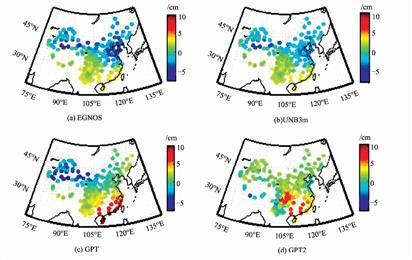 结果显示,4种模型的RMS均为4~5 cm,各模型RMS之差小于1 cm,其中GPT2模型的RMS最小;4种模型的平均偏差(BIAS)为1 cm左右,GPT2模型的BIAS最大,为1.5 cm;时间上,各个模型在夏季精度普遍较低,这是因为夏季水汽丰富,对流层湿延迟变化较大;空间上,各模型在东南沿海精度较低,因为东南沿海气候湿润,湿延迟变化较大;各模型精度对测站高程不敏感,精度在比较高的测站并无明显降低。通过对不同模型在中国区域的精度分析,验证该改正模型可以为中国区域用户的对流层模型的选择提供一定的参考。 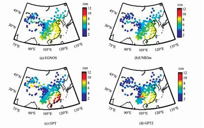 |
| 关 键 词: | 对流层天顶延迟 对流层改正模型 陆态网 精度评定 |
| 收稿时间: | 2015-02-03 |
Interpolation Method of Tropospheric Delay of High Altitude Rover Based on Regional GPS Network |
|
| WANG Jungang, CHEN Junping, WANG Jiexian, ZHANG Jiejun, SONG Lei. Assessment of Tropospheric Delay Correction Models over China[J]. Geomatics and Information Science of Wuhan University, 2016, 41(12): 1656-1663. DOI: 10.13203/j.whugis20140696 | |
| Authors: | WANG Jungang CHEN Junping WANG Jiexian ZHANG Jiejun SONG Lei |
| Affiliation: | 1.Shanghai Astronomy Observation, CAS, Shanghai 200030, China;2.College of Surveying and Geo-Informatics, Tongji University, Shanghai 200092, China;3.College of Transportation Building Engineering Academy, Shandong Jiaotong University, Jinan 250357, China |
| Abstract: | As one of the main error sources in the Global Navigation Satellite System (GNSS), the accuracy of tropospheric delay correction model influences the estimated coordinates, especially in vertical direction; therefore, it is necessary to make assessment of different tropospheric delay correction models. An assessment of four commonly used models, including EGNOS/UNB3m/GPT/GPT2, is made in this paper. The result shows that the RMS of the four models remains 4-5 cm, and the difference between each model is less than 1 cm, with GPT2 being the most accurate model; and the RMS of each model in summer is relatively much bigger than in winter, due to the abundant water vapor in summer, which makes it harder to model tropospheric delay precisely. All models show poor accuracy in southeast China, thanks to the rather changeable weather and the abundant water vapor there; and no model is sensitive to the height, since the accuracy varies little with respect to the variation of altitude. These findings provide a reference for the GNSS users in China area when choosing a suitable tropospheric delay correction model. |
| Keywords: | zenith tropospheric delay tropospheric delay correction model CMONOC accuracy assessment |
| 点击此处可从《武汉大学学报(信息科学版)》浏览原始摘要信息 | |
| 点击此处可从《武汉大学学报(信息科学版)》下载全文 | |