 PDF(8265 KB)
 PDF(8265 KB)
PDF(8265 KB)
PDF(8265 KB)
DEM建模视角下的城市道路分类与表达
Classification and Expression of Urban Road from the Perspective of DEM Modeling
 ({{custom_author.role_en}}), {{javascript:window.custom_author_en_index++;}}
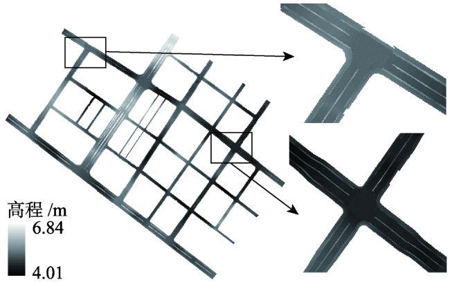
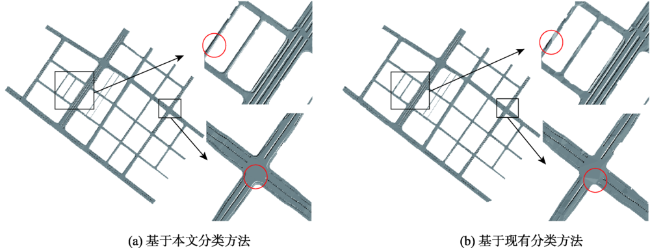
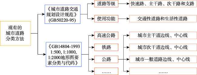
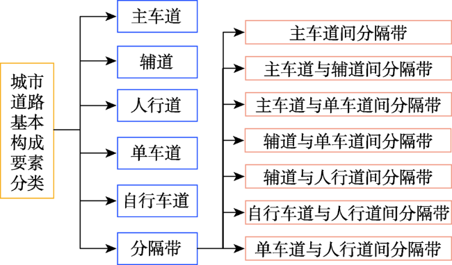
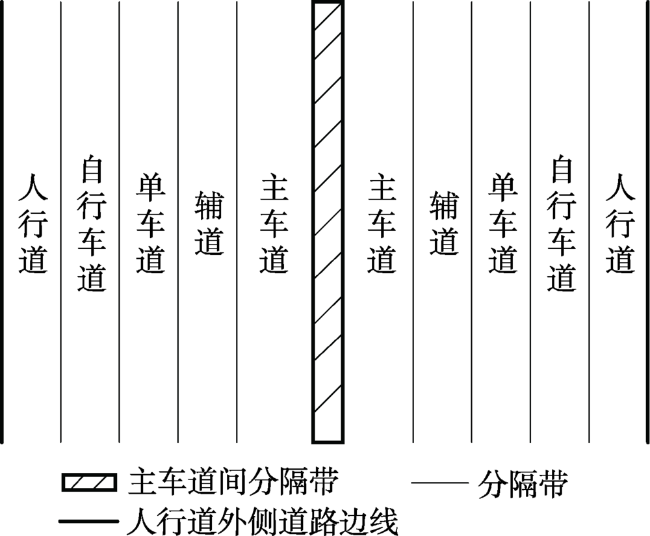
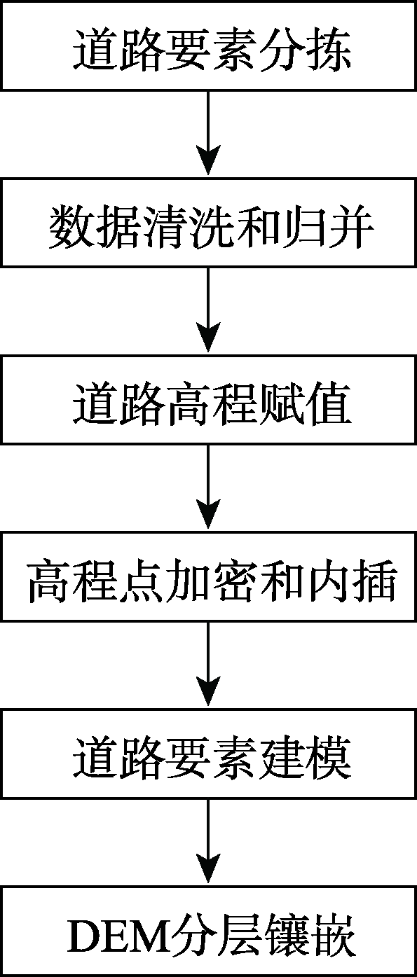
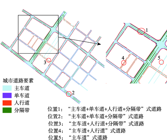
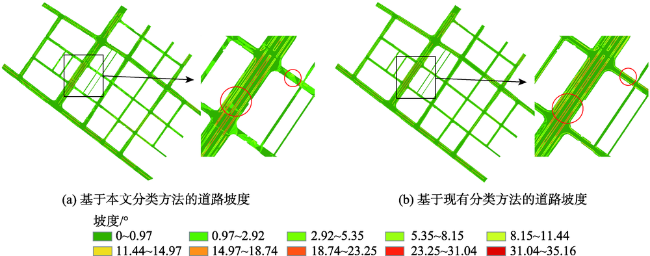
城市数字高程模型(Digital Elevation Model,DEM)是城市最重要的基础地理信息数据之一。城市道路DEM建模是城市DEM构建的重要组成部分,而道路分类是城市道路DEM建模的重要基础和前提。由于现有的城市道路分类方法在城市道路形态表达上有一定程度的失真,无法准确反映道路平面形态特征,导致其难以满足未来的地表过程模拟的需求。针对这一问题,本文从DEM建模视角出发,通过解析城市道路的构成,分析城市道路形态特征,针对现有的道路分类方法的不足,提出了一种顾及道路形态的城市道路分类方法。并在此基础上,探讨了城市道路的DEM表达方式,同时选取南京市局部区域为实验区,以DLG数据为数据源,对本文提出的城市道路分类方法与表达进行了相关的实验与分析。结果表明:与现有的方法相比,基于本文所提出的城市道路分类方法构建的道路DEM所表达的道路形态更符合实际实验区的道路形态,未出现局部路面不正常的突变情况且城市道路要素框架结构明显,所表达的城市道路地形更为精细,可以为雨洪模拟和水文分析等提供重要基础。因此,本文的道路分类方法能够清晰有效地辅助城市道路DEM建模,为高精度城市道路DEM的构建提供基础和参考。
The Digital Elevation Model (DEM) is one of the most important basic geographic information data of a city. Urban road DEM modeling is an important part of urban DEM construction, while road classification is an important foundation and prerequisite of urban road DEM modeling. However, the existing urban road classification methods have a certain degree of distortion in expression of urban road surface. They cannot accurately reflect the planar morphological characteristics of the road, making it difficult to meet the needs of future surface processes simulation. In view of this problem, based on the composition of urban roads, this paper analyzed the characteristics of urban road morphology from the perspective of DEM modeling. An urban road classification method that takes into account the road morphology was proposed to address the shortcomings of existing road classification methods. Based on this, the DEM of urban roads was further explored. In our paper, we selected a subset of Nanjing as the experimental area and used DLG data was as the data source, to further verify the strengths of our urban road classification method. Our results show that the road morphology derived from the road DEM that was constructed based on our urban road classification method was more consistent with the actual road morphology than the existing methods. The framework structure of urban roads was obvious without abnormal changes on the local road surface. The urban road topography was expressed with finer details, which could be used as an important foundation for rain and flood simulation and hydrological analysis, etc. Thus, the road classification method proposed in this paper can assist the modeling of urban road DEM effectively and provide a reference for the construction of high-precision urban road DEM.
数字高程模型 / 城市 / 道路 / 分类 / 数字线划地图 / 地形表达 / 地形建模 / 数字地形分析 {{custom_keyword}} /
DEM / city / road / classification / DLG / terrain expression / terrain modeling / DTA {{custom_keyword}} /
| [1] |
王峥, 孙永华, 李小娟. 顾及地表汇水分析的城市DEM 构建[J]. 地球信息科学学报, 2016,18(12):1608-1614.
[
{{custom_citation.content}}
{{custom_citation.annotation}}
|
| [2] |
李朝阳, 王新军, 贾俊刚. 关于我国城市道路功能分类的思考[J]. 城市规划汇刊, 1999(4): 39-42, 34-80.
[
{{custom_citation.content}}
{{custom_citation.annotation}}
|
| [3] |
刘冰, 颜淋丽, 张涵双, 等. 关于重构城市道路分类体系的探讨[J]. 城市规划学刊, 2014(5):92-96.
[
{{custom_citation.content}}
{{custom_citation.annotation}}
|
| [4] |
孙菲, 宋平, 岳邦瑞. 景观视角下的城市道路分类方法及其特征研究——以西安曲江二期为例[J]. 西安建筑科技大学学报(自然科学版), 2012,44(4):523-528.
[
{{custom_citation.content}}
{{custom_citation.annotation}}
|
| [5] |
杨灿灿, 江岭, 陈昕, 等. 面向城市DEM构建的地形要素分类及表达[J]. 地球信息科学学报, 2017,19(3):317-325.
[
{{custom_citation.content}}
{{custom_citation.annotation}}
|
| [6] |
王春, 汤国安, 刘学军, 等. 特征嵌入式数字高程模型研究[J]. 武汉大学学报·信息科学版, 2009,34(10):1149-1154.
[
{{custom_citation.content}}
{{custom_citation.annotation}}
|
| [7] |
王春, 刘学军, 汤国安, 等. 格网DEM地形模拟的形态保真度研究[J]. 武汉大学学报·信息科学版, 2009,34(2):146-149.
[
{{custom_citation.content}}
{{custom_citation.annotation}}
|
| [8] |
{{custom_citation.content}}
{{custom_citation.annotation}}
|
| [9] |
赵明伟, 张扬, 江岭, 等. 一种优化高精度曲面建模的DEM构建方法[J]. 测绘科学, 2019,44(3):122-126.
[
{{custom_citation.content}}
{{custom_citation.annotation}}
|
| [10] |
周波, 刘学军, 徐俊波. 顾及地形特征语义约束的高保真地形建模方法探索[J]. 地理与地理信息科学, 2017,33(1):8-12.
[
{{custom_citation.content}}
{{custom_citation.annotation}}
|
| [11] |
周波, 刘学军, 徐俊波. 基于语义认知的地形建模[J]. 测绘科学, 2017,42(3):12-17.
[
{{custom_citation.content}}
{{custom_citation.annotation}}
|
| [12] |
{{custom_citation.content}}
{{custom_citation.annotation}}
|
| [13] |
{{custom_citation.content}}
{{custom_citation.annotation}}
|
| [14] |
{{custom_citation.content}}
{{custom_citation.annotation}}
|
| [15] |
{{custom_citation.content}}
{{custom_citation.annotation}}
|
| [16] |
中华人民共和国住房与城乡建设部. 城市道路交通规划设计规范(GB50220-1995)[S]. 北京: 中国计划出版社, 1995.
[ Ministry of Housing and Urban-Rural Development of the People's Republic of China. Code for design of urban road engineering (GB50220-1995)[S]. Beijing: China Planning Press, 1995. ]
{{custom_citation.content}}
{{custom_citation.annotation}}
|
| [17] |
国家技术监督局. 中华人民共和国国家标准1:500、 1:1000、1:2000地形图要素分类与代码(GB/T14804-1993)[S]. 北京: 中国标准出版社, 1993.
[ National Technical Supervision Bureau. Classification and codes for features of 1:500, 1:100, 1:2000 topographic maps (GB/T14804-1993) [S]. Beijing: Standards Press of China, 1993. ]
{{custom_citation.content}}
{{custom_citation.annotation}}
|
| [18] |
汤国安, 李发源, 刘学军. 数字高程模型教程[M]. 北京: 科学出版社, 2010.
[
{{custom_citation.content}}
{{custom_citation.annotation}}
|
| {{custom_ref.label}} |
{{custom_citation.content}}
{{custom_citation.annotation}}
|


 PDF(8265 KB)
/
| 〈 |
|
〉 |


