Comparative analysis of land use/cover change trajectories and their driving forces in two small watersheds in the western Loess Plateau of China |
| |
| Affiliation: | 1. Universidad Central de Venezuela, Facultad de Agronomía, Instituto de Edafología, Maracay, Venezuela;2. Universidad Central de Venezuela, Facultad de Ciencias, Escuela de Computación, Caracas, Venezuela;3. Universidad Rómulo Gallegos, Centro de Investigación y Extensión en Suelos y Aguas, San Juan de Los Morros, Venezuela;1. State Key Laboratory of Desert and Oasis Ecology, Xinjiang Institute of Ecology and Geography, Chinese Academy of Sciences, Urumqi 830011, Xinjiang, China;2. Key Laboratory of Carbon Cycling in Forest Ecosystems and Carbon Sequestration of Zhejiang Province, School of Environmental & Resource Sciences, Zhejiang A&F University, Lin An, Zhejiang Province 311300, China;3. Center for Global Change and Earth Observations, Michigan State University, East Lansing, MI 48823, United States;4. Almaty Branch of Kazakh Scientific Research Institute of Forestry, Ministries of Agriculture, Almaty, Kazakhstan;5. The province Key Laboratory of the Biodiversity Study and Ecology Conservation in Southwest Anhui, College of Life Sciences, Anqing Normal University, Anqing 246133, Anhui Province, China |
| |
| Abstract: | 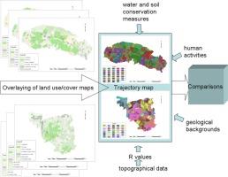
To prevent soil loss and achieve better ecological environments, soil conservation measures have been taken during the past decades in the western Loess Plateau of China. In this paper, a case study was taken in Luoyu valley and Lver valley, two sub-watersheds of Xihe watershed and comparison was carried out between them. The main object of this study is to monitor land use/cover changes in the two similar small watersheds utilizing SPOT5 imageries by object-oriented human–computer interactive classification method, further develop the method of spatio-temporal analysis of land use/cover change by using pattern metrics of change trajectories and relative land use suitability index (R) in smaller watersheds, and make comparisons between the two similar small watersheds, taking water and soil conservation measures into consideration. Results show that combining GIS and RS, this method can be perfectly applied to make comparisons between different small watersheds with similar geographical backgrounds. And land use/cover spatiotemporal dynamic change characteristics can be preferably expressed by pattern metrics of change trajectories and R values based on topographical data. Different emphases have been laid according to their own geological backgrounds in the two watersheds and human activities have different effects on the landscapes of the two watersheds. The main change pattern is from slope farmland to terrace (322, the largest in Luoyu valley) or to economic fruit forest (344, the largest in Lver valley). R value of every slope grade in both of the two watersheds drops with the rising of slope degree on the whole and it shows that there is still much to do for people in the two watersheds in consideration that all the R values are still lower than 0.7. |
| |
| Keywords: | Change trajectories Land use/cover change Landscape metrics Relative land use suitability index Comparative analysis |
| 本文献已被 ScienceDirect 等数据库收录! |
|