|
|||||
|
|
| 基于SPOT5影像自动提取水体的新方法 | |
| 引用本文: | 眭海刚, 陈光, 胡传文, 宋志娜. 光学遥感影像与GIS数据一体化的水体分割、配准与提取方法[J]. 武汉大学学报 ( 信息科学版), 2016, 41(9): 1145-1150. DOI: 10.13203/j.whugis20140460 |
| 作者姓名: | 眭海刚 陈光 胡传文 宋志娜 |
| 作者单位: | 1.武汉大学测绘遥感信息工程国家重点实验室, 湖北 武汉, 430079;2.浙江省第一测绘院, 浙江 杭州, 310012;3.武汉大学遥感信息工程学院, 湖北 武汉, 430079 |
| 基金项目: | 国家973计划(2012CB719906);国家863计划(2013AA122301) |
| 摘 要: | 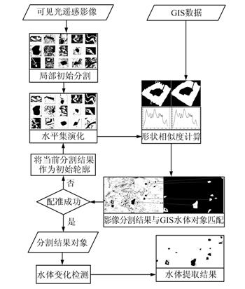 利用遥感影像进行自动化水体提取是一项富有挑战的任务。提出了一种GIS数据辅助下的可见光遥感影像水体自动提取方法,其核心是将影像分割、配准和变化检测集成为一体化处理流程检测水体。 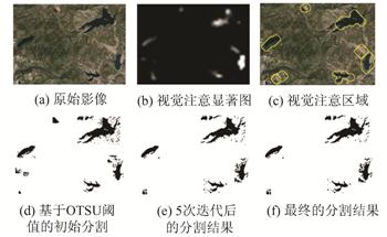 利用水体在遥感影像上的显著特性,首先提出了基于多尺度视觉注意模型的疑似水体区域检测;然后对影像显著区域进行水平集分割处理,通过迭代的分割和配准一体化处理不断优化直至获得最优的分割和配准结果,其中改进的形状曲线相似度特征用于约束分割结果与GIS水体对象的匹配;最后,利用基于缓冲区的变化检测方法获取变化和未变化的水体对象,同时利用已知水体辐射特征与GIS地物的空间位置关系剔除非水体对象。采用3组不同分辨率的遥感影像和不同尺度的GIS数据进行实验,结果显示了本文方法在水体自动提取和变化检测中的有效性。 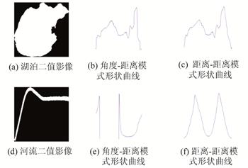 |
| 关 键 词: | 水体提取 GIS 影像分割 配准 变化检测 |
| 收稿时间: | 2015-04-13 |
Satellite Remote Sensing of Earthquake,Volcano, Flood,Landslide and Coastal Inundation Hazards |
|
| SUI Haigang, CHEN Guang, HU Chuanwen, SONG Zhina. Integrated Segmentation, Registration and Extraction Method for Water-Body Using Optical Remote Sensing Images and GIS Data[J]. Geomatics and Information Science of Wuhan University, 2016, 41(9): 1145-1150. DOI: 10.13203/j.whugis20140460 | |
| Authors: | SUI Haigang CHEN Guang HU Chuanwen SONG Zhina |
| Affiliation: | 1.State Key Laboratory of Information Engineering in Surveying, Mapping and Remote Sensing, Wuhan University, Wuhan 430079, China;2.The First Surveying and Mapping Institute of Zhejiang Province, Hangzhou 310012, China;3.School of Remote Sensing and Information Engineering, Wuhan University, Wuhan 430079, China |
| Abstract: | Automatic water-body extraction from remote sensing images is a challenging problem. In this paper, a novel automatic water-body extraction technique is proposed for optical visible remote sensing images. It integrates image segmentation, image registration and change detection with GIS data as a whole process. A new iterative segmentation and registration strategy is also proposed. A multi-scale visual attention model is introduced to detect salient areas and a level-set segmentation algorithm is employed for image segmentation. An improved shape curve similarity (ISCS) method is presented to constrain the matching of image segmentation objects and GIS-identified water-bodies. Furthermore, a buffer-based change detection algorithm was designed to obtain unchanged water-bodies and non-water objects were eliminated with the aid of GIS data and spectral features. Experiments were carried out on three sets of data.Results show that the proposed method was effective in rapid water body extraction and change detection. |
| Keywords: | water-body extraction GIS image segmentation image registration change detection |
| 点击此处可从《武汉大学学报(信息科学版)》浏览原始摘要信息 | |
| 点击此处可从《武汉大学学报(信息科学版)》下载全文 | |